Explore the beauty of asia

#

feel your adrenaline increase when skydiving at whitesunday

Rio de Janeiro

Explore the amazing City

Enjoy the beauty of Bondi Beach

don't miss to enjoy the romantic atmosphere of bondi beach at the night.

This is default featured slide 5 title

Go to Blogger edit html and find these sentences.Now replace these sentences with your own descriptions.This theme is Bloggerized by Lasantha Bandara - Premiumbloggertemplates.com.

Wednesday 24 February 2016

Sua Ocean Trench of Samoa


Samoa volcanic island offering the natural swimming pool as a travel destination which gives incredible experiences. You can enjoy the scenery of crystal clear waters with tropical fishes and pebbles. this place called 'Sua Ocean Trench' which is mean big hole. it is located on lotofaga village, south of Upolu island, Samoa. Sua Ocean Trench formed by volcanic eruption which caused the collapse land surface and formed a big hole with 98 feet depth.

tourists who came to this places not only can witness the scenery, but they also can feel the sensation of fresh waters in this natural pool directly. to reach the bottom of pool, the tourists should descend the stairs. you should be careful while descending the stairs, especially when you use the slippers. because it is very slippery.

in addition, there is a board that can use by the tourist for jumping into the pool. this facility is very appropriate for people who want to feel the sensation of adrenaline. but if you don't want to jump into the pool directly, you can descend the stairs for your safety. the natural beauty's made sua ocean trench assigned as the big five places with the most beautiful nature in the world based on netizen review on the internet.

reported from dailymail, for keeping the serenity of this tourism place and to keep the safety of tourist when they toward to this place and when they swimming in this pool the tourists will charge around $15 for adult and $5 for children.


Tuesday 23 February 2016

Plitvice Lakes Croatia


if you like or have a plan to visit the lake and enjoy the beautiful scenery, then you should come to Croatia. there was one of the most beautiful lakes on earth. it is known as Plitvice lake. It surrounded by 3 mountains and steep cliffs, those are mala Kapela mountain, Dinaric Alps mountain, and medvedek mountain. 

Plitvice Lakes is part of the national park Plitvice in Croatia. everyone who came to this lake said that the Plitvice lake is the most beautiful lake in the world.
Plitvice lake consists of 20 small lakes which form into 1 beautiful big lake. this lake divided into 2 parts, upper part, and lower part. you would be dazzled by beautiful waterfalls while visiting this place. these waterfalls formed by the flow of water from 20 lakes which fall from the upper side of the cliffs. it is really beauty.

in addition, one of the main attraction of this place is the water of these lakes can change into several colors, such as blue, gray, and green. the change in colors  determines by the season and the mineral source which contained inside the water. this beautiful nature panorama can hypnotize all of the tourists who came to this place and make them want to stay longer. you can do some activities on there, such as swimming, tracking, camping, and others.

to reach the central of the lake, you could through a bridge which made from woods. this bridge prepared deliberately by the organizer of the national park for use to cross by every tourist, while you are walking through the bridge, you can enjoy the scenery of east European forest which is beautiful and still naturally. However, you should be careful when visiting this place because this lake located in deep side forest and it made this lake became the water drink source by several wild animals.


so, did you have a plan to visit the plitvice lake?

Tuesday 21 July 2015

Laila Peak, Pakistan

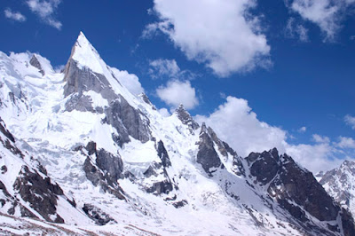
laila-peak-top

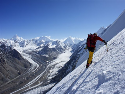
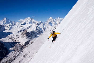
 Laila Peak is a 20,000ft (6096m) high mountain, part of the Karakoram mountain range in Pakistan. Well known for it’s beautiful, distinctive spear-like shape, Laila Peak has only been climbed a few times. Unsurprising given that it’s dramatic northwest face features a 45-degree slope for more than 4900 vertical feet (1500m). Only the most experienced of climbers would dare take on this feat.

The climbing season runs from June until September. Very few climb in the Karakoram Range during the winter months, due to high levels of precipitation. Regardless of which month is chosen, climbing conditions are far from ideal. One of the main issues climbers face is that snow does not always freeze overnight, and climbing this soft snow for long periods is extremely tiring. A team of 4 British alpine climbers, led by Simon Yates in 1987, completed the first ascent. The unofficial ascent was made via the west face from the Gondogoro Glacier, and was later documented by Yates in his biography, the Flame of Adventure, published in 2002.
laila-peak-skiing1

Whilst Laila peak and the nearby village of Hushe in the Masherbrum valley do not lie in a ‘restricted zone’ (an area close to Pakistan’s’ borders), the nearby valleys of Gondogoro and Chogolisa do. This means that if you are a foreign national climbing in these valleys, you will need to purchase a permit and hire a licensed guide.

Laila Peak is situated in central Karakoram, but is quite easy to access from Hushe village, via a road from Skardu. Therefore, to get to Laila Peak, international travellers must first fly into Skardu. From here, trekking companies offer private jeeps large enough to carry passengers and an expedition load. The drive from Skardu to Hushe takes approximately 8 hours. Once in Hushe, base camp can be reached in around 2 days, though it may be wise to take longer, in order to better acclimatise to the high altitude.
skiing-laila-peak

Both Skardu and Hushe feature a range of accommodation options to suit all budgets due to a relatively large number of trekkers passing through. Many climbers choose to make camp on the outskirts of the Hushe village, whilst there are also a number of camping spots on the way to base camp.

Jeita Grotto, Libanon

Jeita Grotto, the longest cave in the Middle East, is located approximately 11 miles (18km) north of Beirut. It consists of two separate, but interconnected, limestone caves, and boasts a length of 5.6 miles (9km). One of the worlds most amazing agglomerations of stalactites and stalagmites, Jeita Grotto is widely considered to be the pride of Lebanon, and featured as a finalist in the New 7 Wonders of Nature competition.
The caves were inhabited by prehistoric man, with evidence suggesting that they were previously used to produce swords. Reverend William Thompson, an American missionary, is credited with the modern discovery of the caves in 1836. Thompson is said to have advanced 50 metres into the caves before firing his gun. The resultant echoes assured him that the caves were to be of significant importance.

Jeita Grotto was not explored further until the 1870’s, when Maxwell and Huxley of the Beirut Water Company carried out extensive expeditions of the caves, reaching 1060 metres inside the grotto. Lebanese explorers have ventured deeper into the cave since the 1940’s, and have so far exposed 5.6mi (9km) of the Jeita Grotto. The caves were initially known as the Grottoes of Nahr al-Kalb, after the underground river that runs through the grottoes. Several names were subsequently used, including Djaita, Jehita, and finally, Jeita. Jeita is derived from the town in which the caves entrance is situated, and is loosely translated in Aramaic as the ‘roar’ or ‘noise’ of water.

A tour of the lower grotto involves a 1650ft (500m) electric boat trip along a subterranean, black lake. At first, you are met with resonant sounds of rushing water and cool air but, as the boat ventures further into the cave, profound silence is experienced. The boat tour provides a marvellous sample of the enormous 20,300ft (6200m) lower grotto. The experienced is enhanced by a lighting system which illuminates the columns and structures within.

Unlike the lower grotto, the upper grotto can be visited on foot. Access is via a specially conceived 384ft (117m) long concrete walkway. Only 2460ft (750m) of the 6990ft (2130m) cave is accessible for visitors. The upper grotto features a large concentration of crystallized formations such as stalagmites, stalactites, ponds, mushrooms, columns, curtains and draperies. Three chambers are accessible to visitors. The first is the white chamber, which features the caves most impressive formations. It is home to the worlds longest stalactite, which measures 27ft (8.2m) in length. The second is the red chamber, which is named due to its colour. The red chamber towers to 106m (348ft) high, and is between 98ft (30m) to 160ft (50m) wide. The third chamber is the highest of the three, at a height of 390ft (120m).

The best way to get to Jeita Grotto is to drive from Beirut. The caves are only 11 miles (18 km) north of Beirut. Another option would be to take a minibus from Dawra to the Jeita turn-off on the Beirut-Jounieh highway. Here, there are taxis waiting who can take you the remaining 3 miles (5km) to Jeita Grotto. Alternatively, you can take a taxi directly from Beirut.

The caves are open for the vast majority of the year, every day of the week apart from Monday. Opening hours vary depending on the time of year, thus, it is advised to check the official website prior to organising your trip. Each year, the caves close for around 4 weeks from late January until early February. During winter, the lower grotto is often closed when the water level becomes too high. The temperature in the caves remains constant at 61 degrees Fahrenheit (16 degrees Celcius) throughout the year. Unfortunately, there is nowhere to stay overnight at the caves. However, there is a range of accommodation options available in Beirut.

Stone Forest National Park, China

Situated close to the bustling city of Kunming in China’s Lunan Yi Autonomous province, Stone Forest National Park is a scenic area boasting an array of captivating limestone formations. Bewitching, dove grey stones, shaped like trees, animals and even fungi, rise up from the earth and point into the heavens, casting eerie shadows. Unsurprisingly, the Stone Forest National Park is very popular amongst tourists who are keen to marvel at its unique rock formations, some of which measure up to 130ft (40m) in height.

Geologists believe that the various rock shapes were created at least 270 million years ago by a combination of natural phenomena. Unique geological conditions contributed to the creation of these clustered rock formations, some of which are said to resemble petrified trees. The peculiar forest landscape covers an area of 135 sq. mi. (350 sq. km) and encompasses a plethora of spectacular vistas. In 2007, two parts of the site, the Naigu Stone Forest and Suogeyi Village, were named UNESCO World Heritage Sites.

According to ancient Chinese folklore, Ashima, a great Yi beauty, was born in the area. She fell in love with Ahei, but was kidnapped by Azhi, the son of the village leader who wanted to force her to marry. Azhi challenged Ahei to a singing competition that lasted for three days but he lost and had to set Ashima free. Whilst on her way back home, Ashima drowned after a river flood caused by Azhi. This is how the rock of Ashima in the small stone forest was formed. Locals now claim that if you call Ashima, she will answer you. Millions of years ago, the ocean would have covered the site that Stone Forest National Park now occupies. Over time, the waters receded, exposing the striking Stone Forest region.

The areas surrounding Stone Forest National Park are home to the Yi or Lolo people. The Yi speak a number of languages and many important works of literature, history and medicine, written in Old Yi script dating back to the 13th century, remain in use. Annually, on the 24th day of the sixth lunar month, Yi people gather in the forest as part of Torch Festival celebrations.

Stone Forest National Park is found just outside the metropolis of Kunming and is open daily, between 8:30AM and 6:00PM. A local saying states: "If you have visited Kunming without seeing the Stone Forest, you have wasted your time". The park is not free to enter; an admission fee is levied. Having paid the entrance fee, day-trippers gain access to a number of fascinating rock formations, sweeping parkland, and dense forest. It is recommended that visitors spend at least two hours on site, as there is much to see.

Both Major Stone Forest and Small Stone Forest feature confounding clusters of looming rock. Major Stone Forest is considered the most elegant and impressive of the two, as bird, animal and human shapes are apparent in its crags and pillars. In Minor Stone Forest, visitors enjoy views of “The Cluster of Pinnacles Propping up the Sky” and “The Stone Singing Praises of Plums”. Ashima’s rock is also situated in the Small Stone Forest, and is considered a sacred symbol of hope and freedom among the Yi people. Primitive art is still in evidence on some of the stones. There is a Karst Geological Museum situated on site, housing over 1200 items, with all descriptions written in English. Having paid the park entry fee, the museum is free to enter. Many tour operators and hotels facilitate daytrips to the Stone Forest. Guided tours of the site are also available at extra cost.


Stone Forest National Park is open all year round. Since its monuments are outdoors, visitors are advised to check the weather forecast before setting out - the region’s tropical climate means that rainfall is fairly frequent. Torch festivities, which include music, dance, and wrestling, generally occur in June. During high season, the park is likely to be crowded with tourists and visitors may have to queue to gain entry. Regular buses to the park run from Kunming East Coast Station (situated on the Eastern edge of Kunming) all year round. By bus, it takes around 2 hours to reach the Stone Forest. Tours can be booked in advance, and day-trippers are best advised to book with reputable tour providers, as touted tours are generally far more costly.

Cenarth Falls, Wales


The cascading Cenarth Falls on the River Teifi are the centrepiece of the village of Cenarth on the border of Pembrokeshire, Ceredigion and Carmarthenshire. The perfect location for a relaxing day trip; keep an eye out for the famous leaping salmon along the river. Take a lovely peaceful walk along the riverbank where you will be met with picturesque views of the River Teifi, the 17th century bridge and finally the breathtaking Cenarth Falls themselves. After you’ve been for a walk, you can stop off at one of the 2 idyllic pubs in the area for a nice cup of tea and a bite to eat.

If you would like to find out more about the history and culture of the area, then be sure to visit the National Coracle Centre, set in the grounds of the 17th century flour mill, along the river Teifi. Here you can take in some of Cenarth's rich history, which centres around the coracle. A coracle is an ancient fishing boat, typically weighing between 25-40 pounds (11-18kg) and built with a basket framework covered with canvas and tar. Fishermen used to walk 5-10 miles up the River Teifi, before drifting back down, hoping to catch salmon or trout. Examples of coracles from all over the world can be found here, including the ones used on the River Teifi.

The easiest way to get to Cenarth is to drive as it is a small village with no train station and limited public bus services. It is well signposted from local areas, and served by either the A484 or the B4332 roads. When you arrive in Cenarth, there is parking available on the north side of the river for a small charge, or a few free spaces can sometimes be found on the south side of the river.

There are a number of small camping grounds and caravan sites in the area, along with one larger holiday park in Cenarth itself. Numerous self-catering cottages can also be found in Cenarth and neighbouring villages. If you are looking to stay in a hotel, your best option may be to stay in nearby Cardigan (7mi/11km).

The Wave, Arizona

The-wave-arizona
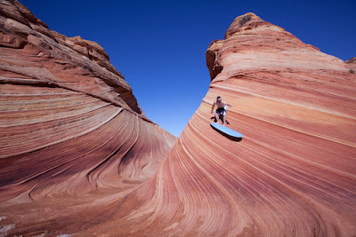
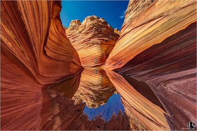
The Wave is a geological marvel found on the slopes of the Coyote Buttes, at the Arizona-Utah border. It’s believed to date back to the Jurassic period during which time prevailing winds pushed the sandy desert dunes across the sandstone, etching it, while water runoff deposited chemicals such as manganese and iron. The resulting bands of color are referred to as the Liesegang rings, named after a German chemist. Swirled bands of color run through the sandstone, ranging from red, pink, orange, yellow, white and green.
the-wave-surving

The formation of the Wave began 190 million years ago, when desert dunes compacted and solidified into striped sandstone. The peculiar and unique fluctuating stratum was created by slow wind and rain erosion. The Wave was virtually unknown until the 1990’s when it was widely advertised in German travel brochures, and featured in the 1996 movie Faszination Natur. 
In order to protect the rock, only 20 visitors are permitted to access the Wave each day. Permits are issued online through a lottery system - more information here. A small permit fee will apply. Despite the limited access to protect the landscape, hikers must remain careful as the Wave has edges that will break easily if stepped upon.
the-wave

Rain storms can make the road to the Wave impassable. They bring numerous pools which form for several days, containing hundreds of tadpoles and fairy shrimp. Reaching the Wave involves a 3-mile hike (6-mile roundtrip) across open desert, with no signposted path to follow. A GPS is therefore highly recommended, as it not unheard of for people to get lost without ever reaching the famous landmark.

The best time of year to visit the Wave is during either spring or fall, as the weather is neither too hot nor too cold. Summer temperatures can exceed 100 degrees Fahrenheit (38 degrees Celsius). Since reaching the Wave requires a 3-mile hike across the open desert (6-mile roundtrip), summer is not an ideal time to visit. During the winter, temperatures are cold at night, but mild during the day, making hiking possible during warmer periods. In order to get the best photographs, visit either during the middle of the day when there are no shadows to be seen, or during the morning/early evening when stark shadows over the land provide dramatic visuals.

The closest towns are Kanab in Utah (77km/48mi) to the west, and Page in Arizona (72km/45 mi) to the east. In both towns, you will be able to find a variety of hotels/guest houses to suit your taste/budget. The drive to the Wave from both Kanab and Page takes approximately 1h20m. Alternatively, there are two campgrounds nearby, the White House Campground, and the Stateline Campground. More information about the campgrounds can be found here.