Explore the beauty of asia

#

feel your adrenaline increase when skydiving at whitesunday

Rio de Janeiro

Explore the amazing City

Enjoy the beauty of Bondi Beach

don't miss to enjoy the romantic atmosphere of bondi beach at the night.

This is default featured slide 5 title

Go to Blogger edit html and find these sentences.Now replace these sentences with your own descriptions.This theme is Bloggerized by Lasantha Bandara - Premiumbloggertemplates.com.

Showing posts with label Africa. Show all posts

Thursday, 16 July 2015

Wli Waterfall, Ghana

Wli Waterfalls is a predominately farming community located in the Hohoe Municipality. It is in fact closer to the Republic of Togo than the capital city of Ghana, Accra. The Akwapim-Togo range provides the perfect setting for what is to become arguably, the most impressive waterfall in Ghana. Some even believe it is the highest waterfall in West Africa. The Wli people like all other Ewes of Ghana originated from the city of Notsie in what is now Benin. The Wli people were led by their King named Togbe Ametornu I and Togbe Afaladze.
Legend has it that Togbe Ametornu I after fighting some many wars successfully decided to take his warriors around to look for food and water. After several attempts through the jungle the King and his subjects came into contact with a river that was pure and tasty. They therefore decided to look for the source of the water that took them across the same river at eleven different locations until they finally heard loud splashing water from the mountains.

They decided to climb the mountain to ascertain the source of the fall. It is believed that at the peak of the mountain, they saw beautiful water falling from the mountain. They named it Agumatsa, “let me flow through, describing the force with which the water is trying to escape from the “throat” of the mountain. This spectacle amazed the people to a great extent that they decided to worship the waterfall as their god. Accounts have been given as to how the river god refused to be photographed until some rituals were performed not only to allow for its photography but to allow women to come closer to it. The day on which the ritual was performed is celebrated as Agumatsa festival which falls on Easter Monday each year.

The forest around the wli waterfall has been preserved into what is known as the Agumatsa wildlife sanctuary. Nature lovers will find this place very interesting to visit. There are about 200 species of birds, 400 butterfly species and fruit eating bats. A visitor/tourist can choose between visiting the upper waterfalls which requires more effect as this calls hiking uphill or the lower falls. The lower falls has a plunge pool where visitors can bathe. 

There river that flows downstream through the woods is so cold that it feels like drinking a refrigerated water. Popular with many ecotourism projects is the provision of alternative forms of livelihoods for natives. Wli is not short of that. There is an ostrich farm where visitors are taking through processes and procedures used in rearing those “giant” birds.

There is no limit to when periods of visitation. Visits can be done throughout the year but during the dry season that starts from October each year and ends in early march the following year the volume of water decreases. The raining season presents the best opportunity to see the falls it is “glory and spender” but that also presents its own challenges. Rainfalls are heavy and usually “unannounced” all the time and conditions become a bit treacherous. However, visitors should not worry about the rains and the terrains since these conditions provide a perfect setting for the adventurous. Visitors or tourists are encouraged to start their tour of the wildlife sanctuary and falls at 8:00am and the falls are opened till 5:00pm each day.
Visitors coming from Accra should take any Accra-Hohoe bound trotro from the numerous trotor stations dotted around the capital. At Hohoe, visitors can obtain more information from the Tourism information centre on how to get to the falls or can just go straight away to trotro station where there numerous trotors and taxi specifically meant for Wli. Those connecting from Ho should also take a Ho-Hohoe trotro from the main lorry station. Follow the steps described above and you will safely get there.

Imlil Valley, Morocco


Imlil is a village in the High Atlas Mountains of Morocco. It is a good starting point for a trekking holiday or for climbing Mt. Toubkal the highest mountain in North Africa (4167m). Imlil village has a variety of shops and "pensions" as well as being a base for guides and trekking parties. The route to Toubkal starts in the village. Its a progressive community and money from tourism goes into a variety of projects organised by the Village association such as litter collection and disposal and a new Community Hammam opened in November 2004.

Imlil is a base for mountain guides and muleteers who work in the area surrounding Jebel Toubkal. It is also a main entry point for those wishing to trek in the mountains in this area. The valley in which Imlil lies is periodically flooded. The most obvious evidence of the most recent flood (1995) is the wreckage of cars on the valley floor north of Imlil. At this point in the mountains, it becomes true Berber country. The almost constant hustling continues, but it feels of a much less threatening nature.

There is an Imlil Village Association which is using money from tourism to address the problems it brings, like litter, as well as start new projects. A local "tax" has been agreed by many of the businesses providing tourist facilities to fund projects. To date a Land Rover Ambulance has been acquired so that the valley population has a safer way of getting to hospital, litter collections have been started and in December 2004 a village Hammam (Community Bath house) has been opened on the little road up to the school. Oddly, while the villages in the next valley don't have running water or electricity, Imlil has its own mobile phone mast: The villagers never stop texting each other. The Imlil Association is part of the "Valleys of Imlil Association" which is an umbrella organisation which other villages are able to join to promote and plan ecologically responsible tourism and infrastructure.Its a great place to go.

What to do?


Trekking is one of the very best things Morocco has to offer In the High Atlas, the country boasts one of the most rewarding mountain ranges in the world. If you are used to the Pyrenees or Alps, here you will feel you are moving a century or so back in time. For all trekking activities (for guides, maps or information) one can pass by Imlil Bureau des Guide just near the main parking. An official mountain guide for Toubkal ascent costs 400 dh/day. Imlil is the starting point for the ascent of Mount Toubkal, the highest mountain in North Africa. There are many guided treks up to the mountain and two refuges,Refuge de Toubkal and Les Mouflons at 3200m altitude for an overnight stay. You should seek guidance locally as to weather conditions.

Imlil is approximately 60 km south of Marrakech, and it can be reached by road through the foothills of the High Atlas Mountains. Grand taxis regularly run to and from Marrakech. The drop off point in Imlil is the scrubby space next to the Hotel-Cafe Soleil at the bottom end of the village, by the river.

By far the quickest and easiest way to get to Imlil from Marrakech is to take a grand taxi, which leave frequently when full (especially in the mornings) from the grand taxi station near Sidi Mimoun Garden. The price for a seat in a grand taxi (May 2015) is 50dh, and the journey time around 75-90 minutes. The road is now fully paved, even beyond Asni. If you can't find a grand taxi then there are other options. It takes about 80-90 minutes to get from Marrakech to Asni by bus. There are buses from the central bus station which ostensibly leave every 30minutes (but often don't for hours). Small minibuses to Asni also leave when full from in front of Sidi Mimoun Garden. A quicker way is to take a petit taxi to the out-of-town grand taxi park (15dh - if you're better at haggling you can get this lower). From there, a grand taxi will take you to Asni (90dh split between 6). Once in Asni there are minibuses and grand taxis that will take you the remaining 18km to Imlil (30 minutes in a minibus (9dh), or 20 minutes in a taxi).

Saturday, 11 July 2015

Mount Kilimanjaro


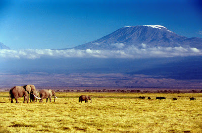
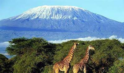
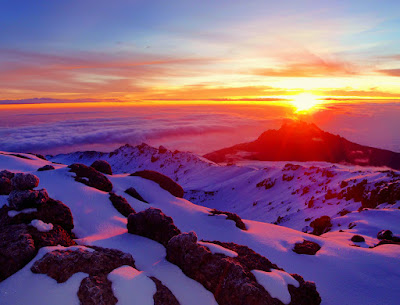
View of mount kilimanjaro
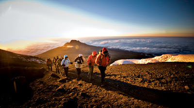
It is an amazing experience to reach the summit of Mount Kilimanjaro. To stand under the signpost for the mandatory picture (for the "Look! I made it! show-&-tell when you come home), enjoying the view of Afica, and knowing that in spite of the cold, the thin air, and the long climb through the night, you have made it to top, is beyond words. 
the-roof-of-africa.jpg


Mount Kilimanjaro is the tallest mountain in Africa, and the worlds highest free-standing mountain with its's 5,895 meters above sea level (19 341 ft). Kilimanjaro is an old vulcano, and consists of three volcano cones; Kibo (5895 m) Mawenzi (5149m) and Shira (3962m). Uhuru Peak is the highest point and lies on the rim of the Kibo crater. The whole mountain is a National Park and there is a wide array of plant and wildlife there. Many species can only be found on here, for example the Kilimanjaro Impatiens, a pretty little flower that grows in the jungle on the mountain floor. Given its proximity to the Equator, and it's hight, climbers can experience 4 different vegetation sones, from jungle forest, through moorland tod alpine desert, with the ice cap at the very top.
kilimanjaro-climb.jpg


Hans Mayer is recognised as he first European to reach the top of Kilimanjaro in 1889. He was not the last. Every year 20 000 people from all over the world come to Mount Kilimanjaro to try and reach the summit, and it has become big business for the locals. Several thousand people work as guides and porters, in addition to the many park rangers that take care of the Naional Park.
mount-kilimanjaro.jpg


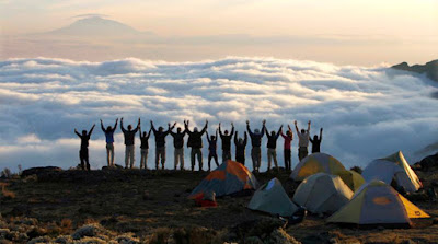
Climbing Mount Kilimanjaro is not easy, though it is the highest mountain one can summit without climbing gear. There are 6 official routes, with various lengths and difficulty level. Marangu route is the shortest (5-6 days), and the only one with huts for accomadation. The other routes are longer, and you sleep in tents. Some are pretty demanding, but the longer approach gives you more time to acclimatise you to the height, wich improves your chance of making the summit.

kilimanjaro-sunrise.jpg


The climb is technically not difficult, but the altitude, the cold and the occationally strong wind makes it a demanding and potentially dangerous climb. One needs to be well prepared, and bring the right gear. Altitude sickness is the biggest danger, it is estimated that about 10 people die on the mountain every year of it. However, for most people it is a matter of walking slowly, taking ones time to acclimatise and drinking lots of water, and going back down, if one does'nt get better.

Friday, 10 July 2015

Azura Benguerra Mozambique

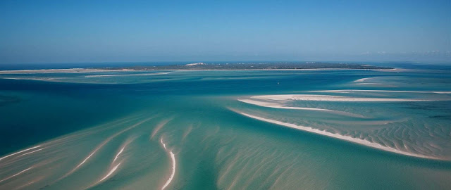
Azura Benguerra from top
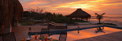
Azura Benguerra is a one-of-a-kind property. Located on Benguerra Island, this is Mozambique's first 'eco' retreat. Built entirely by hand by the local community and operated in partnership with them, this boutique resort has just 17 luxurious villas, each with their own infinity pool and designed for both pampering and barefoot escapism. Two of these accommodate families or couples travelling together, offering the ultimate retreat.

Each villa has a Mozambican butler-host who will take care of every whim and desire, ensuring you have a romantic and memorable stay. From arranging breakfast at the water's edge to serving you a cocktail at sunset, they truly care about making you feel at home here.

Many of the activities on offer are focused around the sea and reefs of Benguerra Island. Guests can snorkel, dive or fish the waters which are abundant with marine life. There are many magnificent reefs which provide a home to the turtles that nest on the island's outer shores. Watch the sunset whilst sailing on a traditional dhow, or cruise to deserted beaches to look for pansy shells. Gaze at the dolphins, who are regular visitors to the beach, or track down humpback whales on their migration past the island’s shores (seasonal). On land, towering sand dunes give way to indigenous bush abundant with local flora and fauna, an interesting variety of birdlife, as well as the odd crocodile or two at the lakes. The island’s local people make for fascinating cultural encounters, and the starry night sky is quite magnificent to behold.
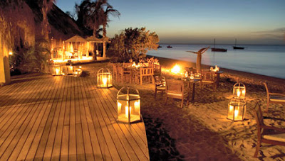
azura dinner

Guests tend to gather each evening in the funky Star Bar before the evening meal is served either in the open-fronted dining room or on the beach. Dining is very much part of your experience here, making the most of the freshest ingredients, accompanied by a superb selection of wine.
Azura villa

Activitties
Many of the activities are focused around the ocean. Guests can snorkel or dive with the PADI 5 Star dive centre with Scuba-pro equipment offering a full range of instructional courses (Padi MSDT Instructor) or there is saltwater fly fishing or big game fishing. Sail on Azura's traditional dhow to look for pansy shells or enjoy a beach picnic on a deserted sandbank.Gaze at the dolphins, who are regular visitors to the beach, or track down humpback whales on their migration past the lodge (seasonal).

There are land based activities too. Take a tour of the island, and experience the local culture or climb the dunes, some of which are scattered with the remnants of ancient Arab pottery. Visit the island’s lakes and spot a crocodile or two. Discover the local fauna and flora. Take a long walk and be met with a picnic. Or join one of the star gazing events and lie back and listen to the ancient African stories that chart the cosmos.


When to Travel

The Bazaruto Archipelago is warm and sunny year round with temperatures averaging 25° C in the winter months (May – August) and over 30° C in the summer months (December - March). Rain is possible from November to March, usually in short bursts. The sea temperature varies with the seasons and currents, and ranges between 22° C and 32° C.

How to get there

It is an 8-hour 30-minute international flight, 2-hour international flight, Azura operates a state of the art 4 seater Eurocopter helicopter for the transfers from Vilanculos to Benguerra Island. The flying time is approx 10 minutes, and will connect with arriving/departing flights. Alternatively guests can transfer by road and speedboat if flying is undesirable. Transfer time is 15 minutes by minibus to the port, then 25-45 minutes by boat depending on sea conditions.

Tuesday, 7 July 2015

victoria falls zimbabwe

Victoria Falls is a town in the western portion of Zimbabwe, across the border from Livingstone, Zambia, and near Botswana. The town lies immediately next to the falls. They are the major attraction, but this popular tourist destination offers both adventure seekers and sightseers plenty of opportunities for a longer stay. Mosikalamosikala (meaning "The Smoke That Thunders"), commonly known as Victoria Falls, is one of the most amazing sights in the world, twice as tall as Niagara Falls and several times longer. Although not the highest, the widest or the greatest volume of water, they have the largest sheet of water for any fall in the world and are a sight not to be missed.
During the Jurassic Period (150-200 million years ago), volcanic activity resulted in thick basalt deposits covering large parts of Southern Africa. As the lava cooled and solidified, cracks appeared in the hard basalt crust, which were filled with clay and lime. Erosion and the course of the mighty Zambezi River cut through these softer materials, forming the first of a series of waterfalls.
Over at least 2000 years, the falls have receded 8 km upstream, as the Zambezi carved its way through seven gorges. This geological history can be seen in the dark basalt in the series of rocky gorges below the falls. It is believed that the Devil's Cataract, which is presently the lowest point of Victoria Falls, will eventually become the next gorge as the river continues to cut its way back upstream.
Essentially, the river falls into a gorge directly in front of the falls, and then flows through a narrow cutting. You can view the falls straight on from across the gorge.


The big question is which side to visit: Zambia or Zimbabwe? There are two things to consider, views of the falls and cost.Two thirds of the actual falls lie within the Zambian territory, as does Livingstone Island, from where David Livingstone first famously set eyes on the falls.
The water from Victoria Falls dives into a narrow gorge running parallel to the face of the falls, with the spray going high into the air, causing permanent rain, rainbows and the famous "smoke" which is visible from a distance, so, much of the time when you are viewing the falls, you are actually facing them. The gorge where the water exits is the limit on how far you can walk from either side. There is no crossing there. This limits your visibility from the Zambian side, as you can walk about only a quarter of the distance of the face of the falls. Although the view and the waterflow is still impressive, you simply cannot get a perspective on the full width of the falls from the Zambian side. 

The walk down to below the falls is closed on the Zimbabwean side. You can only walk down on the Zambian side. The footbridge on the Zambian side gives a unique experience, with a permanent torrential rain from the wet season through to August.
Travelers will have an assortment of visa charges involved in seeing both sides of the falls. The variables include your nationality, single or multiple entry, and whether you will stay longer than 24 hours.
The park is open year-round, but you will get a very different experience depending on the season in which you visit.
feel your adrenaline by swi at devil pool
In the rainy season (December to March), the water volume will be higher, and the falls will be more dramatic. You are guaranteed to get wet if you cross the bridge or walk along the trails winding near the falls. On the other hand, it is precisely because the volume of water is so high that your viewing of the actual Falls will be obscured by all the spray.


In the dry season, (April to October), the water volume will be lower, and by October, Victoria Falls might just be a trickle. You will get a clearer view of the rocky ledge beneath the falls, which is pretty spectacular by itself, but the falls might be somewhat underwhelming. This said, it is still a great experience visiting the falls in the dry season (for instance November), as you can experience both "falls" and the rocky gorge.
 

Great Pyramids of Giza

For nearly 4000 years, the extraordinary shape, impeccable geometry and sheer bulk of the Giza Pyramids have invited the obvious question: ‘How were we built, and why?’
Centuries of research have given us parts of the answer. We know they were massive tombs constructed on the orders of the pharaohs by teams of workers tens-of-thousands strong. This is supported by the discovery of a pyramid-builders’ settlement, complete with areas for large-scale food production and medical facilities. 


Ongoing excavations on the Giza Plateau have provided more evidence that the workers were not the slaves of Hollywood tradition, but an organised workforce of Egyptian farmers. During the flood season, when the Nile covered their fields, the same farmers could have been redeployed by the highly structured bureaucracy to work on the pharaoh’s tomb. In this way, the Pyramids can almost be seen as an ancient job-creation scheme. And the flood waters made it easier to transport building stone to the site.
Inside The Pyramids

But despite the evidence, some still won’t accept that the ancient Egyptians were capable of such achievements. So-called pyramidologists point to the carving and placement of the stones, precise to the millimetre, and argue the numerological significance of the structures’ dimensions as evidence that the Pyramids were constructed by angels or aliens. It’s easy to laugh at these out-there ideas, but when you see the monuments up close, especially inside, you’ll better understand why so many people believe such awesome structures must have unearthly origins.

Step back in time to the days of ancient Egypt on a private tour of the Great Pyramids of Giza and Sphinx, the necropolis of Sakkara and the former capital, Memphis. With your own private Egyptologist guide to lead the way on this private tour, you can determine the amount of time you'd like to spend at each of the sites you'll visit.

The Giza Plateau is only around 30 minutes from Cairo, where your qualified Egyptologist guide will provide a fascinating introduction to each of the three pyramids: Cheops, Khafre and Menakaure. You will have free time to enter one of the pyramids (additional cost), though your guide is not permitted to enter with you, or take a camel ride (additional cost). After visiting the pyramids, you'll continue across the plateau for a photo opportunity of the three pyramids rising from the sands, with the Cairo skyline in the background.

A short drive to the city side of the plateau finds you standing at the feet of the Sphinx, for thousands of years the enigmatic symbol of Egypt. Also in Giza you may visit the Solar Boat Museum (optional), home to the remarkably well preserved funerary boat of Khufu. Your next stop is Sakkara, home of Egypt's oldest pyramid, built in 2650 B.C. Your guide will provide a brief history of the famous Step Pyramid and you'll have free time to walk around. Your final stop is Memphis, the ancient capital of Egypt. Here you will see artifacts from many of the great rulers of Egypt, including the fallen statue of Ramses II. You will also have the chance to visit a Papyrus Institute to see how the famous artwork is made.


Sunday, 5 July 2015

Fish River Canyon


The Fish River Canyon is located in southern Namibia, West Africa. As the second largest canyon in the world, it's a very popular destination among tourists. Although dry with only a small series of pools for most of the year, late summer flooding breathes new life into the 404 mile Fish River. Spectacular panoramic views await visitors of the Fish River Canyon, particularly at Hell's Bend, a scenic overlook named after a horseshoe shaped bend in the river.


With a length of 650 kilometres the Fish River is the longest river in Namibia. Its source lies in the eastern Naukluft Mountains. South-west of Ai-Ais it flows into the Oranje. The Fish River canyon, situated along the lower reaches of the Fish River, is one of the most impressive natural beauties in the southern part of Namibia. With a depth of up to 550 metres, the Fish River Canyon is the second largest canyon in the world. The enormous gorge meanders along a distance of approx. 160 kilometres through the fissured Koubis massif all the way down to Ai-Ais. The canyon starts near Seeheim. It is 161 kilometres long and ends at Ai-Ais.


The Fish River Canyon probably formed about 500 million years ago during the pluvial times - a rainy climatic epoch - many millions of years ago. However, the gorge was not only created by water erosion, but also through the collapse of the valley bottom due to movements in the earth's crust. Because the Fish River is being dammed in Hardap near Mariental, it only contains a small amount of running water. In winter, during the dry season, the river bed is often completely dry or reduced to just some puddles here and there. However, after rainfalls in summer the river can become a raging torrent.
Exteriors of the resort


The canyon is part of a national nature conservation park. The gate is situated at the restcamp Hobas. From there, you have to drive another 10 kilometres to the actual canyon which offers a stunning view of the famous "Hell's Bend".
relax while enjoying the atmosphere of the wild

The Fish River Canyon has become a popular hiking destination. However, hikes require good physical health and can only be undertaken during the cooler winter months (between May and September). A permit from Namibia Wildlife Resorts in Windhoek must be obtained. The hike is 86 km in length and takes about 5 days. Much easier hikes, no less beautiful, are offered in the bordering private "Canyon Nature Park". The adjacent "Gondwana Canyon Park", also private, offers scenic hikes as well. They also have excellent accommodation.
don't miss this atmosphere

Friday, 3 July 2015

Cape Town Beaches

On Cape Town’s Atlantic seaboard, wide sandy stretches, dramatic views and blazing sunsets make up for the bracing sea temperatures that these beaches of Cape Town are known for. While the water might be chilly, Clifton’s four beaches are among Cape Town’s most popular, attracting a trendier set that like to sunbathe, play volleyball and hang out with friends.

Nearby Camps Bay beach is a Cape Town weekend favourite, edged by trendy eateries and characterised by large crowds. A little further on you’ll find Llandudno, a surfers’ paradise rimmed by some of the city’s most expensive real estate, and Sandy Bay, where not even a swimming costume is required.
The warmer Indian Ocean waters of the False Bay seaboard are better suited to swimming. Best known among these beaches is Muizenberg, where multi-coloured Victorian-style beach boxes hark back to a more genteel time.

There are some good Cape Town beaches in nearby Simon's Town, one of the oldest Cape settlements with a strong naval tradition, reflected in the number of naval museums and monuments in the town.
When the wind is up at the beaches in Cape Town, people head to Boulders Beach, which is sheltered by large, rounded rocks and is home to a protected colony of endangered African penguins.
Other popular Cape Town beaches are Noordhoek Beach, which is good for long walks and popular with surfers and kite fliers; Kommetjie Beach, another popular surfers' hangout; and Bloubergstrand, which offers the famous view of Table Mountain across the bay. 

Cape Town is served by an international airport. The beaches themselves are all easily accessible by road and most are served by a variety of bus and tour companies. Best time to visit is Winters are cold and wet, but Cape Town summers have perfect beach weather with extra-long days. Highlights include a trip up Table Mountain, a tour to Robben Island, and a few hours (or days) in the nearby Cape Winelands.
Access to most beaches is free. Some beaches, like Boulders that's in a national park, charge a nominal entrance fee. Cape Town has arguably the highest concentration of restaurants in the country, many of which are found on or close to the beachfront. Try fresh fish or a Cape Malay meal for an authentic taste of the city.