Explore the beauty of asia

#

feel your adrenaline increase when skydiving at whitesunday

Rio de Janeiro

Explore the amazing City

Enjoy the beauty of Bondi Beach

don't miss to enjoy the romantic atmosphere of bondi beach at the night.

This is default featured slide 5 title

Go to Blogger edit html and find these sentences.Now replace these sentences with your own descriptions.This theme is Bloggerized by Lasantha Bandara - Premiumbloggertemplates.com.

Showing posts with label Asia. Show all posts

Wednesday, 24 February 2016

Sua Ocean Trench of Samoa


Samoa volcanic island offering the natural swimming pool as a travel destination which gives incredible experiences. You can enjoy the scenery of crystal clear waters with tropical fishes and pebbles. this place called 'Sua Ocean Trench' which is mean big hole. it is located on lotofaga village, south of Upolu island, Samoa. Sua Ocean Trench formed by volcanic eruption which caused the collapse land surface and formed a big hole with 98 feet depth.

tourists who came to this places not only can witness the scenery, but they also can feel the sensation of fresh waters in this natural pool directly. to reach the bottom of pool, the tourists should descend the stairs. you should be careful while descending the stairs, especially when you use the slippers. because it is very slippery.

in addition, there is a board that can use by the tourist for jumping into the pool. this facility is very appropriate for people who want to feel the sensation of adrenaline. but if you don't want to jump into the pool directly, you can descend the stairs for your safety. the natural beauty's made sua ocean trench assigned as the big five places with the most beautiful nature in the world based on netizen review on the internet.

reported from dailymail, for keeping the serenity of this tourism place and to keep the safety of tourist when they toward to this place and when they swimming in this pool the tourists will charge around $15 for adult and $5 for children.


Tuesday, 21 July 2015

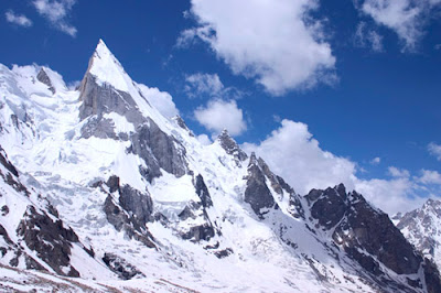
Laila Peak, Pakistan

laila-peak-top

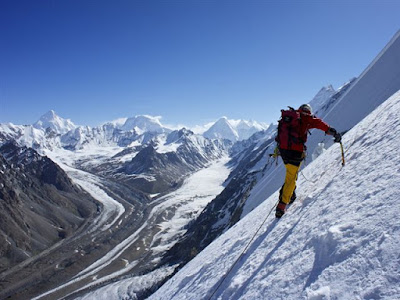
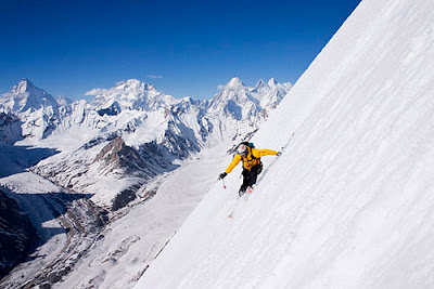
 Laila Peak is a 20,000ft (6096m) high mountain, part of the Karakoram mountain range in Pakistan. Well known for it’s beautiful, distinctive spear-like shape, Laila Peak has only been climbed a few times. Unsurprising given that it’s dramatic northwest face features a 45-degree slope for more than 4900 vertical feet (1500m). Only the most experienced of climbers would dare take on this feat.

The climbing season runs from June until September. Very few climb in the Karakoram Range during the winter months, due to high levels of precipitation. Regardless of which month is chosen, climbing conditions are far from ideal. One of the main issues climbers face is that snow does not always freeze overnight, and climbing this soft snow for long periods is extremely tiring. A team of 4 British alpine climbers, led by Simon Yates in 1987, completed the first ascent. The unofficial ascent was made via the west face from the Gondogoro Glacier, and was later documented by Yates in his biography, the Flame of Adventure, published in 2002.
laila-peak-skiing1

Whilst Laila peak and the nearby village of Hushe in the Masherbrum valley do not lie in a ‘restricted zone’ (an area close to Pakistan’s’ borders), the nearby valleys of Gondogoro and Chogolisa do. This means that if you are a foreign national climbing in these valleys, you will need to purchase a permit and hire a licensed guide.

Laila Peak is situated in central Karakoram, but is quite easy to access from Hushe village, via a road from Skardu. Therefore, to get to Laila Peak, international travellers must first fly into Skardu. From here, trekking companies offer private jeeps large enough to carry passengers and an expedition load. The drive from Skardu to Hushe takes approximately 8 hours. Once in Hushe, base camp can be reached in around 2 days, though it may be wise to take longer, in order to better acclimatise to the high altitude.
skiing-laila-peak

Both Skardu and Hushe feature a range of accommodation options to suit all budgets due to a relatively large number of trekkers passing through. Many climbers choose to make camp on the outskirts of the Hushe village, whilst there are also a number of camping spots on the way to base camp.

Jeita Grotto, Libanon

Jeita Grotto, the longest cave in the Middle East, is located approximately 11 miles (18km) north of Beirut. It consists of two separate, but interconnected, limestone caves, and boasts a length of 5.6 miles (9km). One of the worlds most amazing agglomerations of stalactites and stalagmites, Jeita Grotto is widely considered to be the pride of Lebanon, and featured as a finalist in the New 7 Wonders of Nature competition.
The caves were inhabited by prehistoric man, with evidence suggesting that they were previously used to produce swords. Reverend William Thompson, an American missionary, is credited with the modern discovery of the caves in 1836. Thompson is said to have advanced 50 metres into the caves before firing his gun. The resultant echoes assured him that the caves were to be of significant importance.

Jeita Grotto was not explored further until the 1870’s, when Maxwell and Huxley of the Beirut Water Company carried out extensive expeditions of the caves, reaching 1060 metres inside the grotto. Lebanese explorers have ventured deeper into the cave since the 1940’s, and have so far exposed 5.6mi (9km) of the Jeita Grotto. The caves were initially known as the Grottoes of Nahr al-Kalb, after the underground river that runs through the grottoes. Several names were subsequently used, including Djaita, Jehita, and finally, Jeita. Jeita is derived from the town in which the caves entrance is situated, and is loosely translated in Aramaic as the ‘roar’ or ‘noise’ of water.

A tour of the lower grotto involves a 1650ft (500m) electric boat trip along a subterranean, black lake. At first, you are met with resonant sounds of rushing water and cool air but, as the boat ventures further into the cave, profound silence is experienced. The boat tour provides a marvellous sample of the enormous 20,300ft (6200m) lower grotto. The experienced is enhanced by a lighting system which illuminates the columns and structures within.

Unlike the lower grotto, the upper grotto can be visited on foot. Access is via a specially conceived 384ft (117m) long concrete walkway. Only 2460ft (750m) of the 6990ft (2130m) cave is accessible for visitors. The upper grotto features a large concentration of crystallized formations such as stalagmites, stalactites, ponds, mushrooms, columns, curtains and draperies. Three chambers are accessible to visitors. The first is the white chamber, which features the caves most impressive formations. It is home to the worlds longest stalactite, which measures 27ft (8.2m) in length. The second is the red chamber, which is named due to its colour. The red chamber towers to 106m (348ft) high, and is between 98ft (30m) to 160ft (50m) wide. The third chamber is the highest of the three, at a height of 390ft (120m).

The best way to get to Jeita Grotto is to drive from Beirut. The caves are only 11 miles (18 km) north of Beirut. Another option would be to take a minibus from Dawra to the Jeita turn-off on the Beirut-Jounieh highway. Here, there are taxis waiting who can take you the remaining 3 miles (5km) to Jeita Grotto. Alternatively, you can take a taxi directly from Beirut.

The caves are open for the vast majority of the year, every day of the week apart from Monday. Opening hours vary depending on the time of year, thus, it is advised to check the official website prior to organising your trip. Each year, the caves close for around 4 weeks from late January until early February. During winter, the lower grotto is often closed when the water level becomes too high. The temperature in the caves remains constant at 61 degrees Fahrenheit (16 degrees Celcius) throughout the year. Unfortunately, there is nowhere to stay overnight at the caves. However, there is a range of accommodation options available in Beirut.

Stone Forest National Park, China

Situated close to the bustling city of Kunming in China’s Lunan Yi Autonomous province, Stone Forest National Park is a scenic area boasting an array of captivating limestone formations. Bewitching, dove grey stones, shaped like trees, animals and even fungi, rise up from the earth and point into the heavens, casting eerie shadows. Unsurprisingly, the Stone Forest National Park is very popular amongst tourists who are keen to marvel at its unique rock formations, some of which measure up to 130ft (40m) in height.

Geologists believe that the various rock shapes were created at least 270 million years ago by a combination of natural phenomena. Unique geological conditions contributed to the creation of these clustered rock formations, some of which are said to resemble petrified trees. The peculiar forest landscape covers an area of 135 sq. mi. (350 sq. km) and encompasses a plethora of spectacular vistas. In 2007, two parts of the site, the Naigu Stone Forest and Suogeyi Village, were named UNESCO World Heritage Sites.

According to ancient Chinese folklore, Ashima, a great Yi beauty, was born in the area. She fell in love with Ahei, but was kidnapped by Azhi, the son of the village leader who wanted to force her to marry. Azhi challenged Ahei to a singing competition that lasted for three days but he lost and had to set Ashima free. Whilst on her way back home, Ashima drowned after a river flood caused by Azhi. This is how the rock of Ashima in the small stone forest was formed. Locals now claim that if you call Ashima, she will answer you. Millions of years ago, the ocean would have covered the site that Stone Forest National Park now occupies. Over time, the waters receded, exposing the striking Stone Forest region.

The areas surrounding Stone Forest National Park are home to the Yi or Lolo people. The Yi speak a number of languages and many important works of literature, history and medicine, written in Old Yi script dating back to the 13th century, remain in use. Annually, on the 24th day of the sixth lunar month, Yi people gather in the forest as part of Torch Festival celebrations.

Stone Forest National Park is found just outside the metropolis of Kunming and is open daily, between 8:30AM and 6:00PM. A local saying states: "If you have visited Kunming without seeing the Stone Forest, you have wasted your time". The park is not free to enter; an admission fee is levied. Having paid the entrance fee, day-trippers gain access to a number of fascinating rock formations, sweeping parkland, and dense forest. It is recommended that visitors spend at least two hours on site, as there is much to see.

Both Major Stone Forest and Small Stone Forest feature confounding clusters of looming rock. Major Stone Forest is considered the most elegant and impressive of the two, as bird, animal and human shapes are apparent in its crags and pillars. In Minor Stone Forest, visitors enjoy views of “The Cluster of Pinnacles Propping up the Sky” and “The Stone Singing Praises of Plums”. Ashima’s rock is also situated in the Small Stone Forest, and is considered a sacred symbol of hope and freedom among the Yi people. Primitive art is still in evidence on some of the stones. There is a Karst Geological Museum situated on site, housing over 1200 items, with all descriptions written in English. Having paid the park entry fee, the museum is free to enter. Many tour operators and hotels facilitate daytrips to the Stone Forest. Guided tours of the site are also available at extra cost.


Stone Forest National Park is open all year round. Since its monuments are outdoors, visitors are advised to check the weather forecast before setting out - the region’s tropical climate means that rainfall is fairly frequent. Torch festivities, which include music, dance, and wrestling, generally occur in June. During high season, the park is likely to be crowded with tourists and visitors may have to queue to gain entry. Regular buses to the park run from Kunming East Coast Station (situated on the Eastern edge of Kunming) all year round. By bus, it takes around 2 hours to reach the Stone Forest. Tours can be booked in advance, and day-trippers are best advised to book with reputable tour providers, as touted tours are generally far more costly.

Friday, 17 July 2015

Komodo National Park

Komodo National Park, situated in the heart of the Indonesian archipelago, is consist of three large islands (Komodo, Rinca and Padar), and numerous smaller ones, all of volcanic origin. Perhaps the most dramatic of all Indonesian landscapes, the park features rough hillsides of dry savannah, green thorny vegetation, perfect sandy beaches, and crystal-clear blue waters atop magnificent coral. In addition to its beauty, the park is also renowned for being the only place in the entire world where Komodo dragons exist naturally.

The Indonesian government first established Komodo National Park on the 6th March 1980 to include the islands of Komodo, Padar, Rinca and Gili Motong. Four years later, this area was expanded by Ministerial Decree to include more of the surrounding waters along with a section of mainland Flores. UNESCO has also recognised the parks importance, designating it both a Biosphere Reserve (1986) and a World Heritage Site (1991).

Initially established to protect and conserve the Komodo dragon species, the national park has since developed wider goals to protect the overall biodiversity of the area, both terrestrial and marine. Unfortunately, despite an increased focus on conservation, a number of potential threats remain. For instance, increasing visitor numbers, overdevelopment, fishing and unregulated tourism all serve as threats to biodiversity.

Today, most the inhabitants of Komodo are fisherman originally from other islands. Some descendents of the original Komodo people remain in the region, but their language and culture is becoming increasingly integrated with the migrant population. The early history of the original Komodo islanders isn’t very well documented, with very little known about them other than that they were subjects of the Sultanate of Bima. However, given the remoteness of Komodo from Bima, it is likely they were rarely bothered by the Sultanate other than for occasional tributes.

The most popular activities within Komodo National Park are trekking, scuba diving, and observing the Komodo dragon. The scuba diving and snorkelling in Komodo is world class, with beautiful coral reefs, clear waters, and marine animals in humongous quantities. Furthermore, the warm sea water allows you to focus what you are seeing, rather than think about how cold you are. Walking is also fantastic on the islands, with numerous marked paths available to follow. A particular highlight of trekking in the park is spotting various types of tropical animals and plants that you are unlikely to see in everyday life, along with beautiful scenery in virtually every direction. Finally, seeing the Komodo dragon plays a big part in many people’s reasons for visiting the park. If you do spot one, do not approach, and follow the safety advice given below as they can be dangerous, particularly when hungry.

The typical method of getting to Komodo National Park is from either Labuan Bajo in West Flores, or Bima in Eastern Sumbawa. Flights originate from Denpasar in Bali to these locations on a daily basis. Once at either Labuan Bajo or Bima, you must travel by boat to Loh Liang on Komodo Island, or Loh Buaya on Rinca Island; the main entry points to the park.

Whilst you can visit Komodo National Park year round, the best time to visit is in the dry reason, which runs from April to December. During these months, the weather is beautiful; not too hot, with average temperatures of 79 degrees Fahrenheit (26 degrees Celsius), and very little rain. If you dislike rain, then it is advisable to avoid the wet season, which typically runs from January to March.

If you are visiting specifically to observe the Komodo dragon in its natural habitat, then you should avoid the mating and nesting seasons, which run from July to August, and September to November, respectively. During these periods, spotting the Komodo dragons becomes increasingly difficult. Within Komodo National Park, the only accommodation options available to visitors are simple bungalows found near the ranger’s station. These rooms are not expensive, but you get what you pay for, as they are far from luxurious. If you would prefer to stay in nicer accommodation, you should stay on the nearby island of Bali, where there are many luxurious living spaces available.

Saturday, 11 July 2015

Scuba Diving Holidays at Maldive

maldive landscape
view of maldive landscape
The Maldives is an underwater treasure trove for scuba diving enthusiasts. The unique geographical features of the Maldives coupled with the deep sea channels separating the 26 natural atolls have created an incredibly rich marine ecosystem. The plankton rich waters of the Maldives are home to over 2000 species of fish and uncountable varieties of coral kingdoms.

Popular species that attracts divers from around the world includes; mighty Whale Shark, Turtles, Grey Reef Shark, Napoleon Wrasse, Spotted Eagle Ray, Reef Manta Ray, Whitetip Reef Shark,Blacktip Reef Shark, Moray Eels and Scalloped Hammerhead Shark.

The underwater environment of the Maldives is formed of larger channels, medium channels, inner reefs, lagoons and outer walls of the atolls. Consequently these varying depths have enabled the Maldives to be explored by advanced and beginner divers alike.

The monsoon tides and ocean currents facilitate the natural cleaning and movement of food resources within the pulsating marine setting. You can observe underwater cleaning stations in operation when you dive in the Maldives. In these stations wrasses and shrimps provide cleaning services for larger fish.

The abundance of marine life throughout the Maldives sets the country apart from other diving destinations. Exceptionally the current swept channels and pinnacles act as magnets for drawing an abundance of marine species.

Scuba diving holidays in the Maldives are available throughout the year. Apart from June, all the other months are ideal for scuba diving holidays as visibility is excellent. The water temperature of the Maldives rarely changes and remains constant between 26-29 °C.
There are hundreds of dive sites identified and charted in the Maldives. Explore shipwrecks, underwater caves and caverns while you dive in the Maldives. You can choose between Resort based diving holidays and Liveaboard diving holidays.
The Maldives offer night time scuba diving adventures, macro diving and underwater photography opportunities. Capture stunning imagery of the underwater heaven, as a wonderful recollection of your unforgettable experience in the Maldivian waters.

Thursday, 9 July 2015

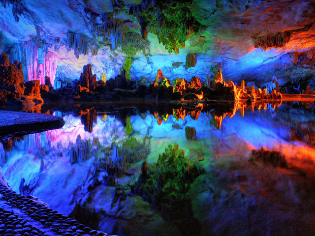
The Reed Flute Cave China

the reed cave
The Reed Flute Cave With location five kilometers northwest of the downtown of Guilin is a natural cave carved out of the karst limestone mountains over millions of years, and has been one of Guilin’s most famous attractions for over 1200 years. The cave got its name from the verdant reeds growing outside, which can be made into melodious flutes. Inside this water-eroded cave is a spectacular world of various stalactites, stalagmites, stone pillars and rock formations created by carbonate deposition and illuminated by multi-colored lighting to create a surreal experience.

240-meter-long cave is lined with interesting rock shapes and formations resembling all kinds of strange things. Many of the formations have taken on recognizable shapes of mythological creatures, or natural images. There are formations that look like vegetables and one even looks like the Statue of Liberty.

Inside, there are more than 70 inscriptions written in ink, which can be dated back as far as 792 AD in the Tang Dynasty. They are travelogues and poems writing by Tang Dynasty literati who visited the cave. These aged inscriptions tell us that it has been an attraction in Guilin since ancient times.
The cave was almost forgotten for a thousand years, before it was rediscovered in the 1940s by a group of refugees fleeing the Japanese troops. The Reed Flute Cave is now marked on almost all travel itineraries.  Each rock formation has been given a poetic name by the Chinese. For instance, you have the Crystal Palace, the Virgin Forest, Dragon Pagoda, and the Flower Mountain.
Despite this evidence of popularity during ancient times, the Reed Flute cave was almost completely forgotten for a thousand years before its rediscovery in the 1940’s by a group of refugees, fleeing Japanese troops. Twenty years later, the cave was formally opened to the public (1962). The enormous ‘Crystal Palace of the Dragon King’ chamber, was once used as a bomb shelter, providing capacity for approximately 1000 people.
A legend surrounds the giant white slab of rock that hangs from the ‘Crystal Palace of the Dragon King’ chamber. It is said to be the Dragon Kings needle, used as a weapon by his enemy, the Monkey King. The Monkey King used the needle to destroy the Dragons army of jellyfish and snails, leaving their petrified remains scattered around the floor of the cave.

Saturday, 4 July 2015

Palau

An untamed paradise for divers and snorkellers, Paula is an archipelago of more than 500 islands, which sprout like giant mushrooms from the crystalline waters of the Pacific Ocean.

The island of Koror is the beating heart of the country and the entry point for most visitors. Home to most of Palau’s inhabitants, it is far from the prettiest island in the archipelago and few choose to linger here. Those who do, however, can grab a slice of Micronesian life in the local bars and restaurants, where charismatic natives take pleasure convincing foreigners to try the local delicacy: fruit bat soup.

Palau is also home to some of the world’s healthiest and most impressive UNESCO-listed reefs. Iridescent corals swirl around the islands, their marine populations teeming with a bounty few other places can match. Indeed, not a list exists that doesn’t rank Palau’s Blue Corner amongst the planet’s top dive sites.

It isn’t just in the tropical seas where strange creatures thrive, for Palau is also home to one of the most ecologically sensitive and unique evolutionary phenomena: Jellyfish Lake. Cut off from the sea millions of years ago, the lake’s predator-free inhabitants have evolved to lose their poisonous sting. To snorkel slowly amongst these gentle creatures is to float through an alien world.

While it’s easy to see Palau's beauty, a closer look will reveal scars from ferocious battles that took place on these shores during WWII. Ship and plane wrecks remain buried in dark lagoons, while long-forgotten bunkers and rusted machine guns are peppered across the islands. This is testament to Palau’s tumultuous modern history, which saw it swap hands from Germany to Japan and, finally, the Untied States, before achieving independence in 1994.

While Palau may be remote and untamed, it is precisely these attributes that make it one of the world’s last unspoiled natural beauties. The archipelago endures as a marvel of Mother Nature, stands proud as a centre for Micronesian culture and offers a haunting memorial to battles once fought in its turquoise waters.
The stunning islands of Palau lie 1,000km (600 miles) east of the Philippines in the middle of the Pacific Ocean. Strung out like emeralds in a necklace, the archipelago stretches over 650km (400 miles) from the atoll of Kayangel in the north to the islet of Tobi in the south. The eight main islands which are inhabited make up the bulk of Palau, but the archipelago includes more than 200 islands, and it is part of the larger Caroline Islands chain which also include the Federated States of Micronesia.

With three exceptions, all of the islands are located within a single barrier reef and represent two geological formations. The largest are volcanic and rugged with interior jungle and large areas of grassed terraces. The Rock Islands, now known as the Floating Garden Islands, are of limestone formation, while Kayangel, at the northernmost tip, is a classic coral atoll.

What to Do?

1.Aquarium
Understand Palau's diverse marine ecosystem better with a visit to the aquarium. Themed exhibits feature varieties of hard and soft corals, some of the region's numerous fish species as well as invertebrates such as the famous stingless jellyfish, giant clams and even crocodiles. The aquarium is part of the Palau International Coral Reef Centre.
2.Babeldaob
Roam around Babeldaob, Palau's biggest island at about 43km (27 miles) long and 24km (15 miles) across at its widest. It is a tropical gem comprising lush, green vegetation, steep mountains, freshwater lakes and sand dunes. It offers great opportunities for driving (4x4s are recommended) or mountain biking with spectacular views.

3.Go Diving
Enjoy Palau's excellent dive sites – considered some of the best in the world – including the famous Blue Corner. Other top sites are Ngemelis Wall, aka the Big Drop-off; the German Channel, known for its manta rays; Siaes Tunnel, an underwater cavern where white-tip reef sharks are common; and Chandelier Cave, where underwater chambers filled with stalactites.

4.Koror
Explore the capital, Koror, the busiest centre in the islands with its many gift and craft shops, a variety of local and international-themed restaurants and other resort facilities. The centre is a bustling and lively hub and it is a wonderful insight into everyday Palauan culture.
5.Swim with dolphins
Look into the eyes of a dolphin as you swim alongside it in the clear, fish-laden waters of Palau. Located just off Koror, the Dolphins Pacific is one of the world's largest marine mammal interaction, educational and research facilities and offers wonderful opportunities to swim with these magnificent creatures.

Where to Stay?

For such a remote place Palau has a surprisingly wide variety of accommodation on Koror and the outlying islands, ranging from first-class five-star luxury resorts with all the facilities and mod-cons, to mid-priced bungalows and motels. There are plenty of beachfront properties – big spenders might like to try the Palau Pacific Resort whilst lovers of more boutique properties should head to the further flung islands. Bear in mind that Palau room rates are relatively expensive, even for rather bog standard accommodation. While Koror has the most options, visitors will find quieter and more secluded accommodation available on the southern islands.

Thursday, 2 July 2015

Kuta Beach

Once a sleepy village with a quiet, beautiful sweep of beach, Kuta today has become a popular beach destination in its own right, alive with tourists from all over the world, swimming, surfing or sunbathing by the beach. Others, casually dressed in shorts, T-shirts and flip-flops stroll along its main road, shopping around or enjoying meals at its many open air restaurants. When in Kuta you know that you are in a holiday town, and people here are in a holiday mood. 

Back in the 1960’s the only hotel was the Kuta Beach Hotel, but soon without much planning, Kuta developed rapidly into a haunt for surfers and backpackers, while the high end market preferred to stay at the more sedate Sanur village on the opposite side of the peninsula.
With time, Kuta’s popularity grew, and shops, restaurants, discos hotels, - from the simple to the exclusive - sprang up along the main road from Kuta to Legian, catering to the ever increasing holiday crowd, that not only included international tourists but also domestic visitors from Jakarta and other big cities. 
On the beach, people enjoy parasailing, banana boat trips or swimming Women offer traditional Indonesian massage on the beach, others are seen plaiting hair. 
Before sunset, crowds rush to the beach waiting to watch Kuta’s legendary sunsets. Then as darkness falls, Kuta’s nightlife starts to throb with loud music from bars and restaurants, while shops stay open till late at night. Kuta’s main attraction is that everyone can enjoy the town without any prescribed dress code. 
Many famous international bands and celebrities have voluntarily played and sung here enlivening the fun, dance and music scene of Kuta. 
One poignant reminder, however, of the tragedy that befell Kuta is a monument located next to the present Paddy’s café. The monument is erected in memory of those killed during the fatal October 2002 bomb terrorist blasts. The blasts killed more than 300 people, mostly Australian tourists and Indonesian workers. 

What to do?

Moving around Kuta its very fun and simple. You can go around on foot or you can rent a bike or motorcycleMany visitors come here to shop.
Kuta is a manufacturing center for summer wear, jewelry and decorative handicrafts that are exported all over the world. So shop here to your heart’s content for summer chic to beach wear, including wonderfully creative accessories from shoes, handbags to bracelets, necklaces and earrings. There are department stores to boutiques, to roadside stalls. Popular night spots on Kuta include the Hard Rock Café, De Ja Vu, the Bali  Globe, Paddy’s Café and many more. 


How to reached?

The first of course you must go to bali island. if you from jakarta, you can get there by flight route Jakarta-Bali. after you landed in bali, kuta beach can be reache by taxi. There are plenty of taxis that can take you to Kuta beach. You can rent these by the meter or by the hour. Taking your own car is not recommended as parking here is very tight.

Where to stay?

Kuta is the ultimate beach resort catering to any taste and budget. You may stay at five star hotels, or at clean “losmen” or home stays. In the hotel complex you will have privacy at the hotel’s own beach front or swimming pool, but when you stroll out you will be met with the hustle and bustle of the town centre. There are various foreign and local restaurants that offering international and local foods. These restaurants are available along Kuta.