Explore the beauty of asia

#

feel your adrenaline increase when skydiving at whitesunday

Rio de Janeiro

Explore the amazing City

Enjoy the beauty of Bondi Beach

don't miss to enjoy the romantic atmosphere of bondi beach at the night.

This is default featured slide 5 title

Go to Blogger edit html and find these sentences.Now replace these sentences with your own descriptions.This theme is Bloggerized by Lasantha Bandara - Premiumbloggertemplates.com.

Showing posts with label America. Show all posts

Wednesday, 24 February 2016

Sua Ocean Trench of Samoa


Samoa volcanic island offering the natural swimming pool as a travel destination which gives incredible experiences. You can enjoy the scenery of crystal clear waters with tropical fishes and pebbles. this place called 'Sua Ocean Trench' which is mean big hole. it is located on lotofaga village, south of Upolu island, Samoa. Sua Ocean Trench formed by volcanic eruption which caused the collapse land surface and formed a big hole with 98 feet depth.

tourists who came to this places not only can witness the scenery, but they also can feel the sensation of fresh waters in this natural pool directly. to reach the bottom of pool, the tourists should descend the stairs. you should be careful while descending the stairs, especially when you use the slippers. because it is very slippery.

in addition, there is a board that can use by the tourist for jumping into the pool. this facility is very appropriate for people who want to feel the sensation of adrenaline. but if you don't want to jump into the pool directly, you can descend the stairs for your safety. the natural beauty's made sua ocean trench assigned as the big five places with the most beautiful nature in the world based on netizen review on the internet.

reported from dailymail, for keeping the serenity of this tourism place and to keep the safety of tourist when they toward to this place and when they swimming in this pool the tourists will charge around $15 for adult and $5 for children.


Tuesday, 21 July 2015

The Wave, Arizona

The-wave-arizona
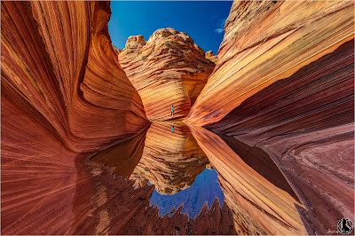
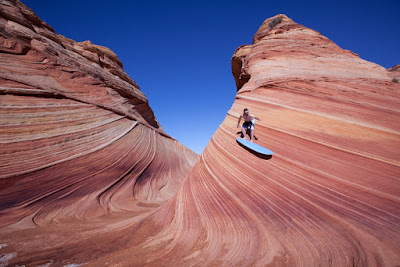
The Wave is a geological marvel found on the slopes of the Coyote Buttes, at the Arizona-Utah border. It’s believed to date back to the Jurassic period during which time prevailing winds pushed the sandy desert dunes across the sandstone, etching it, while water runoff deposited chemicals such as manganese and iron. The resulting bands of color are referred to as the Liesegang rings, named after a German chemist. Swirled bands of color run through the sandstone, ranging from red, pink, orange, yellow, white and green.
the-wave-surving

The formation of the Wave began 190 million years ago, when desert dunes compacted and solidified into striped sandstone. The peculiar and unique fluctuating stratum was created by slow wind and rain erosion. The Wave was virtually unknown until the 1990’s when it was widely advertised in German travel brochures, and featured in the 1996 movie Faszination Natur. 
In order to protect the rock, only 20 visitors are permitted to access the Wave each day. Permits are issued online through a lottery system - more information here. A small permit fee will apply. Despite the limited access to protect the landscape, hikers must remain careful as the Wave has edges that will break easily if stepped upon.
the-wave

Rain storms can make the road to the Wave impassable. They bring numerous pools which form for several days, containing hundreds of tadpoles and fairy shrimp. Reaching the Wave involves a 3-mile hike (6-mile roundtrip) across open desert, with no signposted path to follow. A GPS is therefore highly recommended, as it not unheard of for people to get lost without ever reaching the famous landmark.

The best time of year to visit the Wave is during either spring or fall, as the weather is neither too hot nor too cold. Summer temperatures can exceed 100 degrees Fahrenheit (38 degrees Celsius). Since reaching the Wave requires a 3-mile hike across the open desert (6-mile roundtrip), summer is not an ideal time to visit. During the winter, temperatures are cold at night, but mild during the day, making hiking possible during warmer periods. In order to get the best photographs, visit either during the middle of the day when there are no shadows to be seen, or during the morning/early evening when stark shadows over the land provide dramatic visuals.

The closest towns are Kanab in Utah (77km/48mi) to the west, and Page in Arizona (72km/45 mi) to the east. In both towns, you will be able to find a variety of hotels/guest houses to suit your taste/budget. The drive to the Wave from both Kanab and Page takes approximately 1h20m. Alternatively, there are two campgrounds nearby, the White House Campground, and the Stateline Campground. More information about the campgrounds can be found here.

Friday, 17 July 2015

Bora Bora


Bora Bora is situated approximately 140 miles (225km) northwest of Tahiti, in the western Leeward group of the Society islands of French Polynesia. It is a rugged, volcanic, mountainous island featuring a large lagoon surrounded by beautiful coral reefs and islets. In the Tahitian language, the pronunciation is closer to Pora Pora, and is commonly translated to mean “first born”. Bora Bora was first occupied by Polynesian traders and colonists in the fourth century. In 1722, Dutch explorer Jakob Roggeveen made the first European sighting, but a European would not land on the island until James Cook in 1770. Bora Bora remained an independent kingdom until annexed by the French in 1888.

During World War Two, the island served as a military supply base for the United States. During “Operation Bobcat”, military construction on the island included an airstrip, oil depot, and naval fortifications. After the war, the small airfield would remain the only international airport in all of French Polynesia until 1960. In 2004, all of the French Polynesia islands were granted limited autonomy and citizenship, but would remain under French administration and legal jurisdiction. The permanent population of Bora Bora is quite small, with less than 9000 residents as of 2008. The majority of residents live in Vaitape, found on the western edge of the main island. Tupai, the largest atoll, has a number of coconut plantation workers, but no permanent population. While French is the official language, Tahitian is commonly spoken.

The island of Bora Bora with its spectacular lagoon and beautiful coral reefs is just 11.3 square miles (29,266,865 sq. km) in size. Volcanic in origin, the island is mountainous and jagged, with bare black rock on the higher points. Centered in the island are the remains of an extinct volcano, split into two distinct black stone peaks, Mount Pahia and Mount Otemanu. Pahia is the shorter of the pair, at 2,165 feet (660m), while Otemanu tops out at 2,379 feet (725m). Despite its volcanic origins, there is an abundance of tropical trees, plants and flowers. Common varieties include coconut palms, orange trees, and vanilla plants. The popular noni, a tropical evergreen known for its edible fruit, is abundant.

There are no native mammals on Bora Bora due to its volcanic past. However, due to human activity, there are several non-native species on the island. Cows, horses, and sheep are common, as are dogs and cats. In contrast, there are numerous species of birds found on the island. Black-winged Petrels, Pacific Swallow, and the White Tern are regularly seen. Many other species that are frequently encountered throughout French Polynesia will also be recognized on Bora Bora.
Marine life abounds around in the waters of Bora Bora. Numerous fish species are encountered, including red snapper, jackfish, and lemon sharks. Sea turtles, dolphins, and migrating humpback whales are frequently spotted. Due to the ample marine plankton around Bora Bora, the island is world-famous for the abundant population of ray species, including leopard, eagle and the huge Manta Ray.

The Polynesian summer months, November to April, are often hot and humid. The average temperature during the summer reaches 85 degrees, and the average rainfall is over 10 inches a month. Winter in Bora Bora is slightly cooler, but much drier, with less than 4 inches of monthly precipitation. 
Getting to Bora Bora is relatively easy due to its popularity as a tourist destination. You must firstly fly into Tahiti’s Faa’a International Airport, the only international airport in French Polynesia. Bora Bora is about 140 miles (225km) northwest of Tahiti. You can fly into Bora Bora airport from Papeete. The airport is situated on Motu Mete; a northern islet of the main island of Bora Bora. From the airport, it is necessary to travel by boat in order to get to the main island or resorts on smaller surrounding islands.

Grand Canyon, USA

The Grand Canyon is a majestic steep-sided canyon that attracts an incredible 5 million visitors per annum. Located in the southwestern U.S. state of Arizona, it has an average depth of 1220 meters (4000ft), and is 277 miles (445km) long. The South Rim of the Grand Canyon is the most frequently visited, thanks to its breathtaking views of both the canyon and the Colorado River far below. Interestingly, the Grand Canyon National Park is home to several distinct ecosystems, ranging from desert to forest land. These various ecosystems serve as an ecological refuge for many plants and animals, including many endangered species. Though not the deepest, longest, or widest canyon in the world, the Grand Canyon is renowned for its beauty and awe-inspiring size. The incredible 277-mile long rift divides the Colorado Plateau, forming part of the Colorado River Basin.

Erosion from the Colorado River is responsible for the formation of the canyon. Many estimates suggest that the process began about 6 million years ago. However, a recent study indicated that it might have begun sooner than previously thought - as early as 17 million years ago! Fascinatingly, the walls of the canyon offer an unparalleled representation of Earth’s different geologic phases. In fact, the rocks found in the walls of the Grand Canyon are believed to be approximately 1/3 of the age of the Earth itself.


The average elevations of the Colorado River, South Rim and North Rim are 2200 ft. (above sea level), 6800 ft. and 8000 ft., respectively. This wide range in elevation gives rise to the Grand Canyon’s immense biodiversity. Five of the seven life zones can be found in Grand Canyon National Park, as well as three out of the four main types of desert. As a result, the park boasts over 1500 native plant species, 355 species of birds, 89 mammalian species, 47 species of reptiles, 9 species of amphibians, and 17 species of fish. The park is also home to numerous endangered plant and animal species including the desert tortoise, two species of leopard frogs, the bald eagle, American peregrine falcon, and the bighorn sheep, just to name a few.

The best time of year to visit the Grand Canyon is during either spring or fall, when hiking conditions are ideal, and visitor numbers slightly lower. That is not to say that you should disregard a summer trip to the canyon by any means. However, high temperatures (exceeding 100 degrees Fahrenheit) do not provide ideal hiking conditions and large crowds will be present as it’s the peak tourist season. The winter brings harsh cold (sub-zero) and the chance of heavy snowfall, which may prevent access to either rim. In fact, the road to the North Rim is closed between late-October and mid-May each year.


Fly into either Las Vegas or Phoenix International airports. From here, you can hire a car, or alternatively, book yourself onto one of the many coach tours on offer. The drive to the Grand Canyon from either one of these airports takes approximately 5 hours. To drive to the Grand Canyon, take the Arizona State Route 67 to access the North Rim, or State Route 64 to access the South Rim and Grand Canyon village.

Salar De Uyuni, Bolivia

Salar de Uyuni is the worlds largest salt flat, spanning 4086 square miles (10,582 sq. km) in south-western Bolivia. Unlike traditional deserts, which have sand in abundance, the Salar de Uyuni features vast expanses of glistening white salt. The landscape is entirely flat, bar a few small ‘islands’ such as Isla Incahuasi, which only accentuates its surreal beauty. Underneath the cemented salt are large reservoirs of lithium-rich brine. In fact, approximately 70% of the world’s lithium reserves are found in Salar de Uyuni and thus it’s not surprising that there’s an entire industry devoted to its extraction. Unlike any other place on earth, the Salar de Uyuni is breathtakingly beautiful and provides an extraordinary experience that will not be quickly forgotten.

Containing an estimated 10 billion tonnes of salt, the question often arises as to how Salar de Uyuni was formed. Essentially, the Altiplano (high plateau) here had no drainage outlets, which meant that water from the surrounding mountains once collated to form a giant lake.
High salinity meant that whilst this vast, prehistoric lake has long since evaporated under the fierce Andean sun, a thick crust of salt remains, forming what we now recognise as the salt flats of Salar de Uyuni. Aymaran legend provides an alternative explanation, involving the mountains surrounding the salt flats, Kusina, Kusku and Tunupa. The story is that these mountains were once giant people, and Tunupa and Kusku were married. When Kusku betrayed his wife for Kusina, Tunupa’s tears are said to have formed the salt flats.

The best and most popular way to fully experience Salar de Uyuni is by taking a 4x4 tour across the salt flats. It's worth noting that shared tours usually accommodate for up to 6 tourists, and thus for a more comfortable experience, a private tour should be arranged. Such tours usually involve a minimum of one nights stay in rather basic accommodation, and thus it is recommended that you bring plenty of warm clothes and a warm sleeping bag for the night. Further, sun cream is a necessity as the reflections from the salt accentuate the suns effect.

Adventurous travellers may also wish to try a night’s stay in one of the areas renowned salt hotels. With no building materials around for miles, some locals have taken it upon themselves to build structures from bricks of cemented salt. In these hotels, everything from the beds and tables to the flush toilets are constructed from salt blocks.
Even if you don’t fancy staying, you can usually view these hotels during the day for a nominal fee. In the dry season, Salar de Uyuni is a surreal experience not to be missed. However, rain takes it to a whole new level. As a thin sheet of water covers the flats, it reflects a perfect representation of the sky above so that it is impossible to tell where sky ends and the land begins.

The best time to visit Salar de Uyuni ultimately depends upon the experience you are looking for. For the best climate, we recommend you visit between July and October. However, for an increased chance of seeing the reflective surfaces, you should visit between March and April. Most tours to Salar de Uyuni originate from the small town of Uyuni. To get to Uyuni, you have a number of options available to you.
Most people choose to travel from Ororo, where it is 7 hours by train, or 8 hours by bus. These tickets are quite often booked up on the day, so it is recommended to book in advance. Alternatively, you can take a bus from La Paz (12-15 hours) or Potosi (6-7 hours). Lastly, you can choose to rent a car or fly into Uyuni’s small airport from La Paz.

Thursday, 16 July 2015

Lake O'hara, Canada

Lake O’Hara is a lake situated in the alpine area of Yoho National Park, British Columbia, Canada. Yoho National Park is neighboring with Banff National park and Kootenay National Park all are apart of the Canadian Rockies, There is a limitation to the amount of people that can visit each day in order to protect the sensitive alpine environment. (reservations to reach Lake O’Hara are made 3 months in advance). For more information Check out Parks Canada.

Perched high in the mountains east of Field, Lake O'Hara is worth the significant hassle involved in reaching the place, which is an encapsulation of the whole Rockies. Compact wooded hillsides, alpine meadows, snow-covered passes, mountain vistas and glaciers are all wrapped around the stunning lake. A basic day trip is worthwhile, but stay overnight in the backcountry and you'll be able to access many more trails, some quite difficult, all quite spectacular. The Alpine Circuit (12km) has a bit of everything.

To reach the lake, you can take the shuttle bus from the Lake O'Hara parking lot, 15km east of Field on Hwy 1. A quota system governs bus access to the lake and limits permits for the 30 backcountry campsites. You can freely walk the 11km from the parking area, but no bikes are allowed. The area around Lake O'Hara usually remains covered with snow or very muddy until mid-July.

Make reservations for the bus trip or for camping (a permit costs $10 per night) three months in advance. Available spots often go the first hour lines are open, from 8am mountain time. Given the popularity of Lake O'Hara, reservations are basically mandatory, unless you want to walk. However, if you don't have advance reservations, six day-use seats on the bus and three to five campsites are set aside for 'standby' users. To try to snare these, call at 8am the day before.

Lake O'Hara Lodge has been leaving guests slack-jawed for over 80 years. The only place to stay at the lake without a tent, the lodge is luxurious in a rustic way. Its environmental practices are lauded. There's a two night minimum stay.


Telica Volcano, Nicaragua

The Telíca Volcano is an active volcano about 30 kilometers from León. The latest violent eruption was in 1948, but the volcano has ever since been smoking and grumbling. The volcano is just over a kilometer high (1,061 meters) and has a huge crater: 120 meters deep and 700 meters in diameter.
The hot springs of San Jacinto are connected to the Telíca volcano, even though they are not at the foot of the volcano. San Jacinto is actually one of the places you can start your hike from. It is a long way to the volcano, but because there are no roads that pass by (let alone go up) you have no other choice than to spend most of your time hiking TO instead of ON the volcano.

From San Jacinto you basically walk away from the road and the village, in the direction of the mountain right behind the hot springs. This mountain is not the volcano though. You will walk on a sandy (volcanic sand, actually), little road, filled with rocks and only accessible by foot or horse. This hike will be tough and quite tiring. Besides some corn fields there is only nature around, and you’ll really get an off-road feeling from this hike.
Then, after about three-four hours of walking you will be at the foot of the volcano. Sometimes you can see smoke come out of the volcano, even though the crater is on the other side. The actual climb is not that hard. In one-two hours you can be at the crater. It is never really steep, and there grow lots of trees and plants on the volcano. There are several spots from where you have a great view. Before you reach the crater, you will have to cross a beautiful valley with grassland, trees, and rocks. Just seeing the crater’s walls rising from the valley is impressing.

You can then walk up to the crater’s rim and take a peek if there is no smoke blowing in your direction. If you’re lucky – or if you happen to be there when it’s dark – you will see the lava boiling and glowing in the depth, 120 meters below. This spectacular feeling will even be improved when you look around. The Telíca volcano forms part of the volcanic chain that runs all the way down and includes the volcanoes in Lake Nicaragua. You will see several volcanoes in line, some smoking and others dormant.

Because of the length of the trip, it’s most comfortable to spend the night at the foot of the crater. Several tour-operators organize such trips, and it allows you to rest and also to see a magnificent sunrise from the crater rim. The valley provides a good spot to sleep. Besides the obvious equipment and food you should also bring an extra sweater, especially when you arrive at dusk. There is a strong wind close to the crater, and when you are all sweating this makes it actually very cold without dry clothes. Some tour-operators also offer night hikes: you hike at night, without sleeping, and arrive at the volcano just in time to watch the sunrise. This has the advantage of at least half of the hike not walking in the sun.

Hiking all the way back will take about three-five hours, depending on the group. Because it’s best to spend the night at the volcano – and also because it is hard to find and ascent the volcano without knowing the area –it’s best to hire a guide or go with a tour-operator. It’s also good to bring sun lotion and prepare for some dust-eating, especially in the dry season

Wednesday, 15 July 2015

Creater Lake, Oregon (USA)

creater-lake
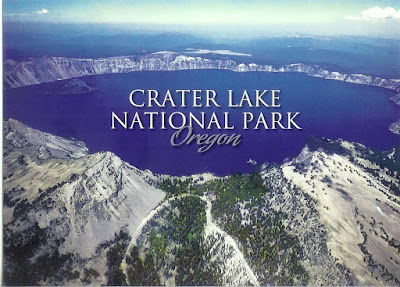
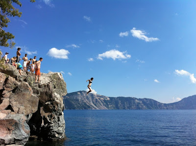
Crater Lake was formed by the collapse of land following a volcanic eruption, it is 2400 meters high at it’s highest point and it is situated in the western  USA, (Oregon). The gloriously blue waters in Crater Lake have been probably one of the most visited places in the United States.


Oregon is home to Crater Lake National Park which is a perfect venue for day hikes.  It is the deepest lake in the United States (which averages around 350 meters in depth ) known for its deep blue color. The blue waters of the Crater Lake reflect the majestic beauty of its surrounding mountain peaks much like a giant dark-blue mirror.Spectacular photographs and gorgeous panoramas taken during a trip to Crater Lake National Park are treasures worth keeping.

Crater Lake was formed due to the collapse of Mount Mazama which was a volcano situated at the southern part of Oregon which once stood approximately 3,353 meters tall ( 11,000 feet). The caldera which measures around 6 miles wide ( 9.7 kilometers) was formed during a series of catastrophic eruptions around 5000 B.C.  Wizard Island is an island which lays just off the west rim of the caldera and was formed due to later Lava eruptions. It was in 1902 when Crater Lake was declared a national park through the efforts of the renowned naturalist- William Gladstone Steel.

There are plenty of things to do when you visit Crater Lake National Park. The south entrance is the most popular alternative route to visit this national park. It is said to be open all –year round. Though this entrance, you will access Mazama Village and the Rim Village along with the park headquarters right at the Steel Visitors Center.
During the winter season, visitors are only allowed to go up to the rim of the lake and back down the same way. There will be no plowed areas to serve as road. On the other hand, the north entrance is only open from the early days of June to late October depending on the amount of snowfall.

Saturday, 11 July 2015

Belize


Sandwiched between Mexico, Guatemala and the shimmering Caribbean Sea, Belize occupies a slice of paradise that is packed with culture, wildlife and a wondrous selection of historical sites. Much of the mainland remains swathed in jungle, where the vestiges of ancient cities punctuate verdant forest canopies. Caracol is the most famous. Its crumbling temples and stone pyramids stand as powerful reminders of the Maya civilisation.

The history is fascinating for sure, but most people visit Belize to see its natural wonders and admirable conservation work; the Cockscomb Basin Wildlife Sanctuary was the first jaguar sanctuary in the world; the island of Half Moon Caye has been entirely dedicated to the conservation of birds; and the protected Belize Barrier Reef harbours an incredible array of marine life. Visitors can swim with sharks and stingrays along colourful walls of coral, or explore the Blue Hole, renowned as one of the world’s best dive sites. Numbering fewer than 335,000, Belizeans have surprisingly diverse roots: the country is a melting pot of Creole, Garifuna, Mestizo, Spanish, Maya, English, Mennonite, Lebanese, Chinese and East Indian heritage. Racial harmony, religious tolerance and a relatively peaceful political culture, have allowed these different elements to blend successfully and have given Belize a reputation as a friendly, laidback destination.

Belize’s towns and cities are small and, on the whole, pleasantly unexciting. San Ignacio is a charming enough stop-off for those disappearing into the jungle and Punta Gorda offers insightful home stays with some of the country’s last remaining indigenous communities. The somewhat bland capital, Belmopan, however, is hardly worth going out your way for and bustling Belize City, though energetic and ruggedly charming, is used largely as a gateway to the islands. And what exquisite islands they are. Caye Caulker, Ambergris Caye, Cayo Espanto (to name a few) are everything you expect from the Caribbean and more; swaying palms, pellucid waters, sandy shores, ramshackle beach bars and charming restaurants. All that’s missing are the crowds. Go figure.

Things to see and do...

Caracol Ruins
The archaeological site of Caracol is one of Belize’s remarkably well-preserved Mayan sites. This one is noteworthy because of transport there: due to its proximity to the Guatemalan border, it is strongly advised to travel there in police convoy, flying over the bumpy terrain, for tourist safety.
Actun Tunichil Muknal Cave
A short drive from San Ignacio, visiting Actun Tunichil Muknal Cave is a full day of jungle hiking followed by wading, swimming and climbing through a vast ancient cave used by the Mayans for sacrifice to the gods. This trip is not for the claustrophobic or faint-hearted, but it is possibly the best thing to do in Belize.
Ancient ruins
Wander through the exquisitely carved Xunantunich ruins, considered some of the most beautiful and intricate in the Mayan world. The ruins date from AD200 to 900 and are found close to the Guatemalan border.
Blue Hole
Plummet into the depths of the Blue Hole: the startlingly vivid blue sinkhole measures 300m (1,000ft) across and over 120m (400ft) deep and is considered one of the best dive sites in the world. Take plenty of water and cover for your head – the boat trip out there is a long one.
Caye Caulker
The cayes off the coast are the reason most people visit Belize, and Caye Caulker is the quiet, laid-back one. Windsurfing or kite-surfing here is magic: the water is so clear beneath, it may be possible to spot fish, stingrays and even dolphins. The best wind conditions usually occur from February to June.
Explore the Cayes
Belize’s most popular spot, Ambergris is the place to go for diving and snorkelling. The reefs and diving spots here are world class. It also has the most nightlife in the country and excellent seafood. The main town here is San Pedro, made famous in Madonna’s ‘La Isla Bonita’.