Explore the beauty of asia

#

feel your adrenaline increase when skydiving at whitesunday

Rio de Janeiro

Explore the amazing City

Enjoy the beauty of Bondi Beach

don't miss to enjoy the romantic atmosphere of bondi beach at the night.

This is default featured slide 5 title

Go to Blogger edit html and find these sentences.Now replace these sentences with your own descriptions.This theme is Bloggerized by Lasantha Bandara - Premiumbloggertemplates.com.

Showing posts with label Europe. Show all posts

Tuesday, 23 February 2016

Plitvice Lakes Croatia


if you like or have a plan to visit the lake and enjoy the beautiful scenery, then you should come to Croatia. there was one of the most beautiful lakes on earth. it is known as Plitvice lake. It surrounded by 3 mountains and steep cliffs, those are mala Kapela mountain, Dinaric Alps mountain, and medvedek mountain. 

Plitvice Lakes is part of the national park Plitvice in Croatia. everyone who came to this lake said that the Plitvice lake is the most beautiful lake in the world.
Plitvice lake consists of 20 small lakes which form into 1 beautiful big lake. this lake divided into 2 parts, upper part, and lower part. you would be dazzled by beautiful waterfalls while visiting this place. these waterfalls formed by the flow of water from 20 lakes which fall from the upper side of the cliffs. it is really beauty.

in addition, one of the main attraction of this place is the water of these lakes can change into several colors, such as blue, gray, and green. the change in colors  determines by the season and the mineral source which contained inside the water. this beautiful nature panorama can hypnotize all of the tourists who came to this place and make them want to stay longer. you can do some activities on there, such as swimming, tracking, camping, and others.

to reach the central of the lake, you could through a bridge which made from woods. this bridge prepared deliberately by the organizer of the national park for use to cross by every tourist, while you are walking through the bridge, you can enjoy the scenery of east European forest which is beautiful and still naturally. However, you should be careful when visiting this place because this lake located in deep side forest and it made this lake became the water drink source by several wild animals.


so, did you have a plan to visit the plitvice lake?

Tuesday, 21 July 2015

Cenarth Falls, Wales


The cascading Cenarth Falls on the River Teifi are the centrepiece of the village of Cenarth on the border of Pembrokeshire, Ceredigion and Carmarthenshire. The perfect location for a relaxing day trip; keep an eye out for the famous leaping salmon along the river. Take a lovely peaceful walk along the riverbank where you will be met with picturesque views of the River Teifi, the 17th century bridge and finally the breathtaking Cenarth Falls themselves. After you’ve been for a walk, you can stop off at one of the 2 idyllic pubs in the area for a nice cup of tea and a bite to eat.

If you would like to find out more about the history and culture of the area, then be sure to visit the National Coracle Centre, set in the grounds of the 17th century flour mill, along the river Teifi. Here you can take in some of Cenarth's rich history, which centres around the coracle. A coracle is an ancient fishing boat, typically weighing between 25-40 pounds (11-18kg) and built with a basket framework covered with canvas and tar. Fishermen used to walk 5-10 miles up the River Teifi, before drifting back down, hoping to catch salmon or trout. Examples of coracles from all over the world can be found here, including the ones used on the River Teifi.

The easiest way to get to Cenarth is to drive as it is a small village with no train station and limited public bus services. It is well signposted from local areas, and served by either the A484 or the B4332 roads. When you arrive in Cenarth, there is parking available on the north side of the river for a small charge, or a few free spaces can sometimes be found on the south side of the river.

There are a number of small camping grounds and caravan sites in the area, along with one larger holiday park in Cenarth itself. Numerous self-catering cottages can also be found in Cenarth and neighbouring villages. If you are looking to stay in a hotel, your best option may be to stay in nearby Cardigan (7mi/11km).

Wednesday, 15 July 2015

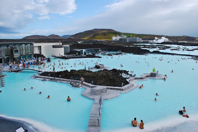
Blue Lagoon Iceland "The Geothermal Spa"

view-blue-lagoon
Blue Lagoon
The Blue Lagoon is one of Iceland’s most popular attractions drawing the attention of hundreds of thousands of tourists every year.  The lagoon is actually a geothermal spa fed by water from a nearby geothermal plant.  The water originates near a lava flow from 6,000 feet at its deepest level (2,000 meters). The actual lagoon sits on a Lava field and the walls that surround the walkway (the very long walkway) were built from actual lava rock that comes from the field.  When you swim in the lagoon you technically are swimming on top of two different continents.  Iceland sits on top of the  Mid Atlantic Ridge where the North American and European plates are separating at roughly 2 centimeters a year.
feel-the-spa-sensation

Above you can see the first view of the lagoon right before you enter the facilities, notice the lava field on all sides.  Being 45 minutes away from the biggest city in Iceland, Reykjavik, you have to either take a tour or find other means of transportation.  Being roughly 25 minutes from the airport many tour operators package Iceland tours to the Blue Lagoon and the airport together.  You can have a relaxing day at the spa and then catch your flight in the afternoon.

The Blue Lagoon Iceland is a tourist trap by any definition as there are many other geothermal spas that you can visit throughout Iceland (some that are actually free).  The current costs to get in as of 2010 are 28 Euro to enter, 5 Euro for a towel, 5 Euro for a bathing suit, and 9 Euro for a bath robe. You read that right, they charge you for towels and a robe,  so in the end it doesn’t come out that cheap.  
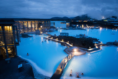
night-view-blue-lagoon
Night View
That doesn’t include the costs for food if you are going to eat there or for any of the premium services like the skin treatments, massages, and restaurants.  Even though it can get a bit pricey there are ways to keep your costs down by bringing your own towel, you dont need the robe.  I would still recommend that you visit the Blue Lagoon because it really is a great thing to experience.

I would recommend that you visit in the winter (no im not crazy) for three reasons;  the first being that you wont enjoy a geothermal spa as much in hot weather, the second is that you cant see one of the most popular things to do in Iceland in the summer which are the Nothern Lights, and the last reason is that you will avoid the heard of tourists that arrive in the summer.  Who would want to sit in 100 degree water at the Blue Lagoon Iceland in the summer anyway?  It will get cold so make sure to bring a jacket along with your towel.  Once you step into the lagoon you will feel a slight slushy feeling on your feet which is the silica mud that many have found medical refuge in.  Its known to be an effective treatment for psoraisis and other skin ailments.

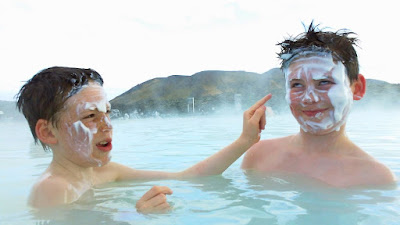
You can enter the water from outside the facilities or from inside so you dont have to step out into the cold weather in the winter.  After entering the kids pool as I like to call it, the Blue Lagoon Iceland surprises you with a waterfall that you can sit by and enjoy (no time limits!).  I must have stood there for at least 15 minutes because it really felt like a water massage.  As you start to find your way around the lagoon there are certain canisters where you can scoop the silica mud and place it on your face.

They aren’t kidding when they say this stuff is magical.  Once you pick it up the silica mud it feels very slimy with little stones inside.  Once you place it on your face you wait for it to dry and start to peel it off.  It feels like cement when you start to peel it.  After you get it all off your face starts to tingle like when your arm goes to sleep.  It’s not as strong of a sensation but I did stare at the mirror a little longer than usual before I walked out because it felt that much different.

Wednesday, 8 July 2015

Santorini Greece


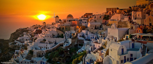
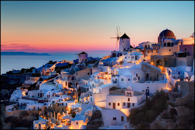
sunset at santorini island
Santorini is a volcanic island in the Cyclades group of the Greek islands. It is located between Ios and Anafi islands. It is famous for dramatic views, stunning sunsets from Oia town, the strange white aubergine (eggplant), the town of Thira and naturally its very own active volcano. There are naturally fantastic beaches such as the beach of Perissa, maybe the best beach in Santorini, the black pebble beach of Kamari, white beach and red beach.An alternative name for Santorini is Thira. Santorini is also a name for the family of islands surrounding Thira, once forming a single island prior to a major volcanic event in approximately 1628 B.C.E.
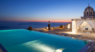
swimming pool with a beautiful view on santorini resort
The small island cradles a rich variety of landscapes and villages. Visit traditional architecture in the small village of Mesa Gonia containing a mixture of ruins from the 1956 earthquake and restored villas as well as a winery at the foot of the settlement. Pyrgos is another notable village set inland with its grand old houses, remains of a Venetian castle and several Byzantine churches.
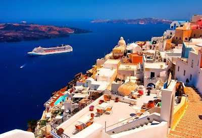
cruise ship santorini
The island has one natural source of fresh water, a small spring situated in a cave behind a small chapel located halfway up the steep footpath between Kamari and the entrance to Ancient Thira. It only provides a small quantity; it is of good quality as it comes from the only remaining limestone outcrop of the pre-volcanic island. Prior to the early 1990's, it was necessary for water to be delivered to the island via tanker from Crete. However, most hotels and homes now have access to water provided by a local desalination plant. While this water is potable, it is still rather salty, so most everyone drinks bottled water while visiting Santorini.
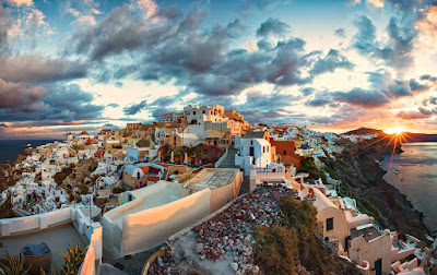
Sunrise at santorini
Santorini is one of the great natural wonders of the world, and its main attraction is the landscape and seascape of the island itself. The configuration of the present, roughly semicircular island is the result of an enormous volcanic explosion which occurred probably around 1630 bce, literally blowing the top off the island and changing what had been a typical half-submerged mountain of an Aegean island into a flooded crescent caldera, in the middle of which a few small smoking islands still bear witness to volcanic activity. Some have speculated that this event was the inspiration for the myth of Atlantis. The towns of Fira, Ia (also known as Oia) and Thirasis cling to the steep cliffs facing into the caldera bay. Tours to the central "smoking" islands are readily available and one can see and feel steam vents and recent (1950s) lava flows. Another popular reason for coming to Santorini are the legendary sunsets, some of the most spectacular in the world. Ia is one of the few places on the island which is both close to a sea and offers a good view to a sunset over the sea: in other towns, the sun disappears behind the volcano.
View santorini
Fira is the fiery capital, a marriage of Venetian and Cycladic architecture, whose white cobblestone streets bustle with shops, tavernas, hotels and cafes, while clinging to the rim of the caldera nine hundred feet above the its port. If arriving by sea you can take a cable car up from the port or alternatively take a trip on one of the hundreds of mules up the 588 zigzagging steps. You could also attempt to walk up the steps but be warned, they are winding, narrow in parts with only low walls, they are covered in donkey excrement and the donkeys themselves will make no attempt to avoid you.Walking north from Fira for about twenty minutes will bring you to Imerovigli, where you can take in the magnificent views of the island’s unique scenery from the tiny town. 
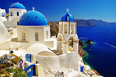
At the northern end of the caldera is the quintessentially Santorininian town of Oia, also spelled Ia and pronounced EE-ah, with its whitewashed walls sunk into the volcanic rock and its blue domes rising above the sterling beauty of the stunning, russet Ammoudi Bay. At dusk, the town attracts crowds of people venturing to see the sunset. Santorini's sunsets, as viewed from Oia, are reputed to be among the world's most beautiful.
Santorini Accomodation.
Getting in from Athens by air is faster and not prone to sea sicknessSantorini (Thira) National Airport is an airport in Santorini/Thira, Greece (IATA: JTR, ICAO: LGSR), located north of the village of Kamari. With regular flights from Athens by Olympic Air, Aegean Airlines and AirSea Lines (a seaplane airline). Flight duration to santorini from Athens is about 30 minutes. During summer, Sky Express  connects Santorini with other popular islands such as Crete (Heraklion), Rhodes and Mykonos. During the months of July and August Astra Airlines  flies from Thessaloniki.
Santorini Beach
by sea...

Take the ferry from Piraeus past Paros and Naxos to the new port of Athinios  on Santorini. More details in the Cyclades article. There is also daily connection between Heraklion (Crete) and Santorini during high season. If you prefer traveling by sea, your best bet is high-speed catamarans. The trip from Pireaus to Santorini takes 4.5hrs with a high speed ferry. Ferries dock at the new port of Athinios, where buses and taxis meet each arrival to transport passengers to Oia, Fira, and elsewhere. All vehicles climb a very steep, winding road (with seven 180 degree turns) to get anywhere from Athinios. If you arrive by cruise ship
View of santorini villas
the experience will surely leave you with lasting memories. Cruise ships that call on Santorini do not dock but hold position in the caldera near the Old Port of Fira and require tendering, which is usually provided by the Union Boatman of Santorini. Locals with fishing boats occasionally transfer cruisers to the Old Port at Fira (Skala Pier, which seems not to have changed over the last 50 years)
.
.

Monday, 6 July 2015

St. Moritz


St. Moritz originally rose to importance because of its healing mineral springs and healthy climate, which have been appreciated for over 3,000 years. Already in the middle Ages, visitors came to St. Moritz to take the waters. Today, St. Moritz is one of the best-known and most prestigious ski resorts in the world, especially since having hosted the Olympic Winter Games in 1928 and in 1948. The name "St. Moritz" stands for a chic, vibrant and elegant town, second home to the rich and famous, enjoying a special atmosphere and a dry, tingling champagne climate with 322 sunshine days yearly.

Meteora Greece

The Meteora are a collective of natural sandstone rock pillars, which have served as places of worship throughout modern history. With an average elevation of 313m (1027ft), the Meteora rocks stand proudly at the centre of an extraordinarily beautiful Greek landscape, housing 24 monasteries in total, of which 6 remain active. Inscribed on the UNESCO World Heritage List in 1988, Meteora attracts tourists to the region in their thousands each year.


The name, ‘Meteora’ stems from the Greek adjective, meteoros, which means ‘middle of the sky’. Aptly named, the rock formations of Meteora jut out of the ground like giant fingers made of stone, allowing the various monasteries to sit, suspended in the air. It has taken millions of years for various forces of nature to sculpt out these unique rock pillars. Geologists believe that this process began approximately 60 million years ago during the Palaeogene period.

 interior of monastery
As early as the 11th century, monks occupied the caverns of Meteora. However, monasteries were not built until the 14th century, when the monks sought somewhere to hide in the face of an increasing number of Turkish attacks on Greece. At this time, access to the top was via removable ladders or windlass. Nowadays, getting up is a lot simpler due to steps being carved into the rock during the 1920’s. Of the 24 monasteries, only 6 (five male, one female) are still functioning, with each housing less than 10 individuals.


Meteora is not only a paradise for walkers, but for climbers too. In total, there are 700 different routes, encompassing 120 rock towers of the Meteora, and catering for climbers of all skill levels. If you are travelling with the intention of climbing, the best times to visit are between mid-March to mid-June or between mid-August to mid-November.


Given the cultural significance and popularity of Meteora, there are visitors all year round. Between December and March, the weather is cold and wet, whilst the months in-between July and October attract the largest crowds and peak season rates. Therefore, the best time to visit Meteora is in May or June in order to benefit from smaller crowds, pleasant weather and off-season rates.


The Meteora rocks are situated right in the heartland of central Greece (Thessaly), near the town of Kalampaka. To get to Kalampaka from Athens (218mi / 352km), you have the option of traveling by bus, car, or train. If you have a car, driving is probably the best way to get to Meteora, and should take approximately 4 hours, notwithstanding any traffic. If driving is not an option, you can take a direct, high-speed train from Athens to Kalampaka, which will take around 5 hours. Finally, and as a last resort, there are buses that can take you from Athens to Trikala, and then from Trikala to Kalampaka. These depart from Terminal B on Liosson Street and take 7-8 hours to arrive.

Saturday, 4 July 2015

Matterhorn


Situated in the Pennine Alps on the border between Switzerland and Italy is one of the most famous and distinctive of all Alpine peaks. The Matterhorn is a pyramidal-shaped colossus, standing at a skyline-dominating 4478 metres (14,690 feet). Its four steep faces rise above the nearby glaciers and face the four compass points, north, east, south and west. Although not the highest peak in the Alps its fame is due to its almost impossible shape; an unusual landform with a summit that appears to extend over its north face, making it look like a cobra about to strike.
The formation of the Matterhorn (and the rest of the Alps) began some 50 to 60 million years ago when the African and Eurasian tectonic plates collided, and layers of sedimentary rock that had formed in the seas between them were thrust up above sea level. Experts suggest that the Matterhorn began as a rounded hill, but gained its distinct pyramidal shape as a result of natural erosive forces over the last million years.
The first successful ascent of this iconic peak was on July 14, 1865 by a team led by English illustrator, climber and explorer Edward Whymper. He had previously made several unsuccessful attempts on the summit. The climb was marred by tragedy as four team members lost their lives in a fall just below the summit during the descent. The second ascent occurred just three days after Whymper’s triumph, from the Italian side. The mountain’s difficult north face wasn’t climbed until July 31 and August 1, 1931.
The Matterhorn’s north face overlooks the Swiss Zmutt Valley, whilst the south stands guard over the Italian ski resort village of Breuil-Cervinia. The Theodul Pass, a trade route used by Ancient Romans and Celts as early as 100BC connects the two destinations. Unknown to most, the Romans originally named the Matterhorn, ‘Mons Silvius’. In fact, it wasn’t until sometime during the 1500’s that Germans named the mountain, the Matterhorn, derived from “matte” meaning meadow and “horn” meaning peak
climbing route
The climbs are long and demanding and it’s essential that climbers have previous alpine mountaineering experience. The usual route is up the Hörnli ridge, also called the North-East ridge. This is the central ridge that can be seen from the village of Zermatt at the foot of the mountain. The ascent starts at Hörnli Hut, a mountain hut situated at 3,260 metres (10,700 ft.) above sea level. It involves 4,000 feet of climbing and takes around six hours up and five hours down. There are fixed ropes on some parts of the climb. Although this is considered the easiest ascent it has an AD (fairly difficult) rating. Other routes on the mountain include the Zmutt ridge, the north face, and the Italian ridge (South-West or ‘Lion’ ridge) which was the route taken by the party that reached the summit three days after Whymper.
zermatt camp
If you are attempting to climb the Matterhorn the best times are from mid-July to mid-September, depending on the amount of snow on the mountain. However, it’s important to bear in mind that the weather on the mountain is dangerously unpredictable and changes commonly occur throughout the day.
ermatt is the world-renowned resort village at the foot of the Matterhorn, boasting luxury hotels, boutiques, restaurants and health spas. It is situated in the canton of Valais in the west of Switzerland.
milky way from matterhorn
International flights into Switzerland arrive at either Geneva or Zurich airports, with both providing easy access to Zermatt through the Swiss rail network. Train is the most convenient way to get to Zermatt as it is a car-free village. Only electric cars are allowed to operate within its boundaries.

Cinque Terre Italy


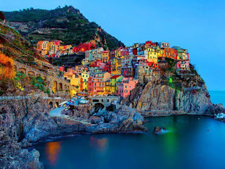
If you ever get tired of life, bypass the therapist and decamp immediately to Cinque Terre. Here five crazily constructed fishing villages, set amid some of the most dramatic coastal scenery on the planet, ought to provide enough to bolster the most jaded of spirits. A Unesco World Heritage Site since 1997, Cinque Terre isn't the undiscovered Eden it once was but, frankly, who cares? Sinuous paths tempt the antisocial to traverse seemingly impregnable cliffsides, while a 19th-century railway line cut through a series of coastal tunnels ferries the less brave from village to village. Thankfully cars – those most ubiquitous of modern interferences – were banned over a decade ago.

Rooted in antiquity, Cinque Terre's five villages date from the early medieval period. Monterosso, the oldest, was founded in AD 643, when beleaguered hill dwellers moved down to the coast to escape from invading barbarians. Riomaggiore came next, purportedly established in the 8th century by Greek settlers fleeing persecution in Byzantium. The others are Vernazza, Corniglia and Manarola. Much of what remains in the villages today dates from the late High Middle Ages, including several castles and a quintet of illustrious parish churches.

Buildings aside, Cinque Terre's unique historical feature are the steeply terraced cliffs bisected by a complicated system of fields and gardens that have been hacked, chiselled, shaped and layered over the course of nearly two millennia. So marked are these artificial contours that some scholars have compared the extensive muretti (low stone walls) to the Great Wall of China in their grandeur and scope.

In October 2011 flash floods along the Ligurian coast wreaked havoc in Vernazza and Monterosso, burying historic streets and houses under metres of mud and killing half-a-dozen people. As of 2013, most businesses are open again, but check the status of the Sentiero Azzurro (blue walking trail) before you set out.

Enjoy a full-day tour visiting the beautiful Cinque Terre (the five lands) where a rugged portion of coast on the Italian Riviera is punctuated by picturesque small fishing villages. After driving through Tuscany into Liguria, stop in the first Cinque Terre village of Corniglia. Enjoy panoramic views and take spectacular pictures of the land and coast.
After a walk through the delightful village, stop at one of the local bars for a glass of wine accompanied by bruschetta.Your second stop is at the village of Vernazza, arguably the most beautiful of the five villages with a large open harbor, castle and church. Enjoy some free time to walk around and have a relaxing lunch (own expense) at one of the open-air restaurants that lines the waterfront, or take a stroll through the back streets for impressive views along the coast.After your visit to Vernazza, meet your tour escort at a prearranged time for your shared boat ride to Riomaggiore.
While on the boat, ogle the dramatic coastline from the water, framed against the hills. Riomaggiore is the most southern village of the Cinque Terre and its houses are built along the cliff face. Follow your tour escort for a walk around the village and then travel to pretty Manarola.Manarola is one of the oldest villages of the Cinque Terre. Explore the narrow alleys and pretty pastel squares that epitomize the beauty of the area, and perhaps sample some renowned local wine at a cozy wine bar (own expense). After visiting Manarola, leave the Cinque Terre and make your way back Florence where you'll arrive in the early evening.

Thursday, 2 July 2015

Arc de Triomphe


If anything rivals the Eiffel Tower as the symbol of Paris, it’s this magnificent 1836 monument to Napoleon’s 1805 victory at Austerlitz, which he commissioned the following year. The intricately sculpted triumphal arch stands sentinel in the centre of the Étoile (‘star’) roundabout. From the viewing platform on top of the arch (50m up via 284 steps and well worth the climb) you can see the dozen avenues.

Av de la Grande Armée heads northwest to the skyscraper district of La Défense, where the Grande Arche marks the western end of the Axe Historique.
The most famous of the four high-relief panels at the base is to the right, facing the arch from the av des Champs-Élysées side. It’s entitled Départ des Volontaires de 1792 (Departure of the Volunteers of 1792) and is also known as La Marseillaise (France’s national anthem). Higher up, a frieze running around the whole monument depicts hundreds of figures, each one 2m high.
Beneath the arch at ground level lies the Tomb of the Unknown Soldier. Honouring the 1.3 million French soldiers who lost their lives in WWI, the Unknown Soldier was laid to rest in 1921, beneath an eternal flame which is rekindled daily at 6.30pm.
Don’t cross the traffic-choked roundabout above ground if you value your life! Stairs lead from the northern side of the Champs-Élysées beneath the Étoile to pedestrian tunnels (not linked to metro tunnels) that bring you out safely beneath the arch. Tickets to the viewing platform are sold in the tunnel.